
From Lauterbrunnen to Griesalp over the Sefinenfurgge
A very long day in the mountains: you leave Lauterbrunnen station, climb up to Mürren, cross the Sefinenfurgge, the highest point, and head down into the Kiental to Griesalp. This is stage 12 of the Via Alpina, in its official direction. Allow 9 h 00 of walking and 2,000 m of climbing: it is rated difficult for fitness and medium for technique, on a mountain trail.
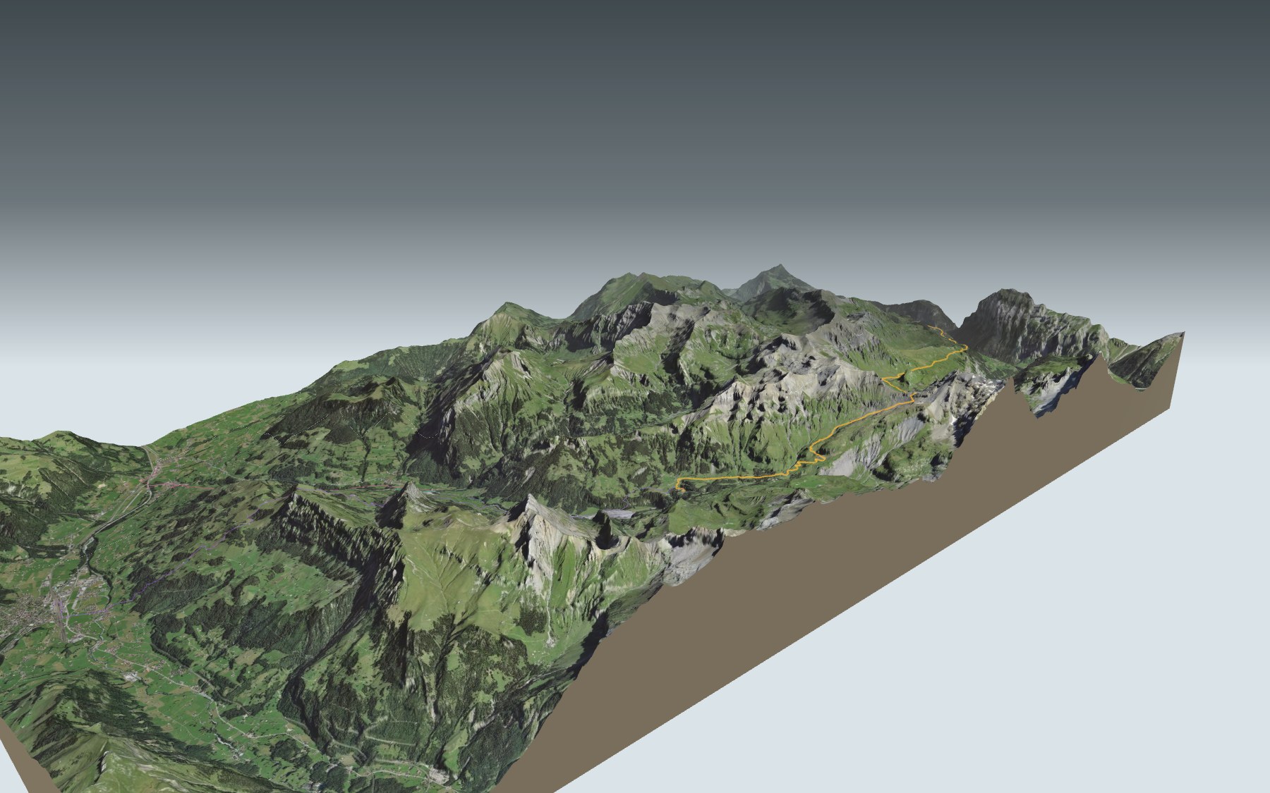
The climb starts right at the station, through the forest, along the Louwibach and then the Staubbach, and carries on beside the railway to Mürren. Next come the Spielbodenalp, the Bryndli, the Rotstockhütte and the last climb, steeper and steeper, up to the pass. On the other side, a steep descent on steps, then the Dürreberg down to Griesalp. The elevation profile shows you where it gets hardest.
The 3D map also shows three other routes to Griesalp, from Kiental, Reichenbach or Frutigen: they come up the Kiental and only join this trail at the very end, without crossing the pass. Their estimated times are in the list of starting points. The day before, you can reach Lauterbrunnen on Grindelwald → Lauterbrunnen; the day after, carry on with Griesalp → Oeschinensee → Kandersteg. Above Mürren you will also find the Mountain View Trail.
After Mürren, stops are few: Gimmeln, a little off the trail, the Spielbodenalp, the Rotstockhütte, then no place to eat listed near the trail before the Naturfreundehaus Gorneren, shortly before the end. Bring water and food. At Griesalp, the PostBus goes back down the Kiental to Reichenbach. Check the next departures and plan your day before you set off. Looking for more in the area? All hikes in the Bernese Oberland.
The story of the trail
What happened where you are going to walk, chapter by chapter.
A long day, two valleys
You start at 796 m, at Lauterbrunnen station, and finish at 1,410 m, in Griesalp. In between: 22.5 km, 2,000 m of climbing and 1,400 m of descent, with a high point of 2,613 m at the Sefinenfurgge. The official time is 9 h 00 in this direction and 8 h 25 the other way.
This is stage 12 of the Via Alpina, walked in its official direction: from the Lauterbrunnen valley to the Kiental. It is a mountain trail, rated difficult for fitness and medium for technique. Set off early, and follow the signposts and the conditions on the day.
From the Staubbach to Mürren, beside the train
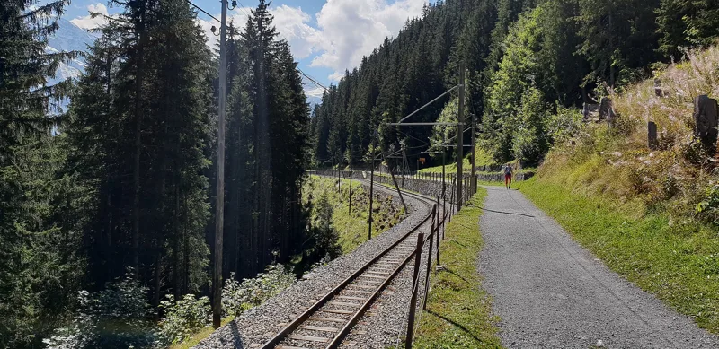
From the station, the path climbs steeply through the forest. Around km 1.3 it crosses the Louwibach, then around km 2.0 the Staubbach: shortly after, this stream becomes the Staubbach Falls, the highest free-falling waterfall in Switzerland. Around km 3.9, at Winteregg, the path meets the railway and follows it to Mürren; the Bergrestaurant Winteregg is 232 m from the trail.
This mountain line, from Grütschalp to Mürren, was built in 1891. Before it, tourists could only get up to Mürren by mule. Today its trains pass each other at Winteregg station.
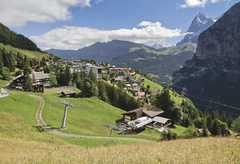
Mürren, the old Walser settlement
Around km 5.5 you walk into Mürren. The place is recorded as early as 1257; it was probably a summer pasture until settlers arrived after 1300, mostly from the Lötschental. Mürren and Gimmelwald, Walser settlements, are first mentioned in 1346. The village community built the first hotel in 1857. Until the First World War, the British were the most numerous guests, and Mürren had an Anglican church as early as 1878.
Mürren is closed to motor traffic, and it is the highest village lived in all year round in the canton of Bern. The Inferno ski race has been held here every year since 1928. Under your feet, in the village, the trail crosses the Mürren Breccia, a limestone rock from the late Eocene that contains nummulites and takes its name from the village.
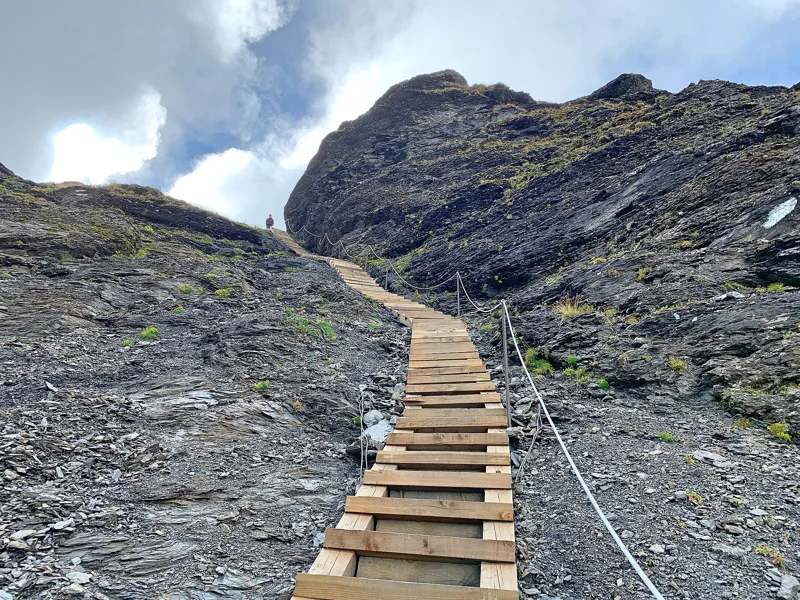
Up to the pass, on volcanic sandstone
After Mürren you leave the road for a path that zigzags steeply up through the meadows, with the Gspaltenhorn ahead. At km 8.5, the Spielbodenalp, then the Bryndli, around km 9.8. At km 12.3, the Rotstockhütte looks down on the Sefinental, a valley the barons of Wädenswil sold in 1240 to the Augustinian priory of Interlaken. In 2026 the hut announced it would be open until 29 September, then closed for the winter until June 2027, with no winter room.
The climb gets steeper and steeper up to the Sefinenfurgge, at km 15.4. From the pass, the view takes in the Schilthorn, the Kiental and the Blüemlisalp. Just before the pass, and again on the way down, the geological map shows Taveyannaz sandstone, made mostly of volcanic fragments; it is named after the Taveyanne pasture, near Gryon, in the canton of Vaud. At the pass, it shows rocks from the Jurassic.
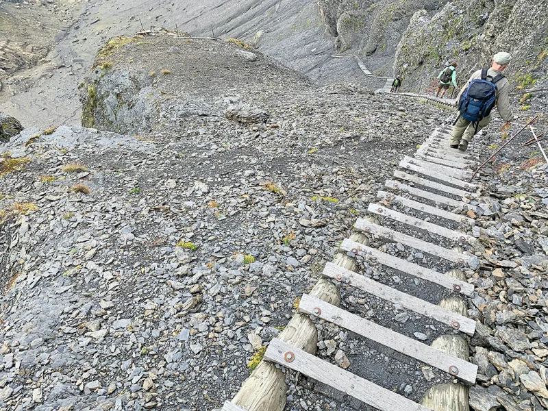
Down into the Kiental
On the other side, the descent is steep, on steps and rocky paths, before giving way to a meadow. The path follows the stream, passes close to a waterfall, then reaches the Obere Dürreberg. From the pass to Griesalp, it crosses the Kiental federal game reserve, listed in the federal inventory of game reserves.
At km 21.9, Golderli, then Griesalp, at km 22.3. From here the PostBus heads back down to Reichenbach: between Tschingel and Griesalp is the steepest stretch of the whole PostBus network. From 24 to 30 April 1916, in Bern and in the village of Kiental, further down the valley, socialists opposed to the war, from nine countries and including Lenin, held a secret conference. Further down the page you'll find the next departures.
Every way to Griesalp
4 starting points to reach Griesalp. Pick yours: the 3D view shows it and “My day” recalculates.
Walking times without breaks. “Estimated” times are calculated on the terrain profile with a model fitted to the official stages; the shortest path may differ from the one on the yellow signposts: on the ground, follow the signs. Gradient: the steepest over 200 m of trail. Profiles share the same scale (length and altitude). Stations and car parks within 500 m of the start.
In pictures
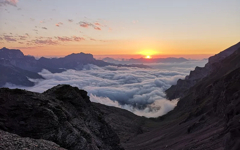
Sea of clouds over the Kiental from the Sefinenfurgge pass
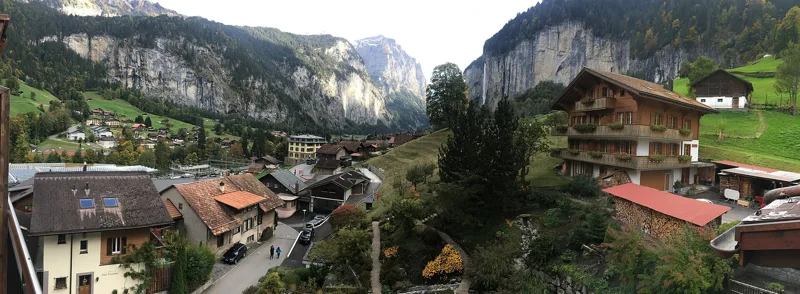
Lauterbrunnen and the Staubbach Falls
The Lauterbrunnen-Mürren mountain railway between Mürren and Winteregg, with a path alongside
Hiking trail at Mürren, with the Bernese Alps behind
Mürren, with the Eiger on the right
Alpine sea holly (Eryngium alpinum) at Mürren
Pond between the Rotstockhütte and the Sefinenfurgge pass
The steps up to the Sefinenfurgge pass, on the Sefinental side
Alpine salamander on the way to the Sefinenfurgge
Hiker heading down just below the notch of the Sefinenfurgge
Lauterbrunnen → Griesalp: when to go
Public transport serves the start every day of the year, according to the official timetable. Here the sun clears the ridge late, and the latest time to set off ranges from 11:23 in June to 6:41 in December.
- Public transport to the start
- every day
- 91 to 132 arrivals a day
- first arrival 0:23, 0:26 or 6:23
- last 23:26 or 23:27
- Sun at the start, mid-January
- from 11:18
- rises at 8:08, hidden by the ridge
- Leave by, for 9 h 00 of walking
- 7:07
- arrive 1 hour before sunset, at 17:07
| Month | Sun at the start | Leave by | In the sun, leaving at 9:00 | Transport |
|---|---|---|---|---|
| December | 11:26 → 16:41 | 6:41 | 36 % | every day |
| January | 11:18 → 17:07 | 7:07 | 43 % | every day |
| February | 10:02 → 17:53 | 7:53 | 64 % | every day |
“In the sun”: the share of the path in sunlight under a clear sky, with the terrain worked out point by point. The path climbs to 2,613 m: today's snow and frost are in the weather and My day.
- Public transport to the start
- every day
- 95 to 132 arrivals a day
- first arrival 0:23 or 0:26
- last 23:27
- Sun at the start, mid-April
- from 9:27
- rises at 6:41, hidden by the ridge
- Leave by, for 9 h 00 of walking
- 10:16
- arrive 1 hour before sunset, at 20:16
| Month | Sun at the start | Leave by | In the sun, leaving at 9:00 | Transport |
|---|---|---|---|---|
| March | 9:11 → 18:33 | 8:33 | 85 % | every day |
| April | 9:27 → 20:16 | 10:16 | 98 % | every day |
| May | 8:44 → 20:55 | 10:55 | 100 % | every day |
“In the sun”: the share of the path in sunlight under a clear sky, with the terrain worked out point by point. The path climbs to 2,613 m: today's snow and frost are in the weather and My day.
- Public transport to the start
- every day
- 114 to 132 arrivals a day
- first arrival 0:23 or 0:26
- last 23:27
- Sun at the start, mid-July
- from 8:48
- rises at 5:50, hidden by the ridge
- Leave by, for 9 h 00 of walking
- 11:19
- arrive 1 hour before sunset, at 21:19
| Month | Sun at the start | Leave by | In the sun, leaving at 9:00 | Transport |
|---|---|---|---|---|
| June | 8:36 → 21:23 | 11:23 | 100 % | every day |
| July | 8:48 → 21:19 | 11:19 | 100 % | every day |
| August | 9:14 → 20:39 | 10:39 | 99 % | every day |
“In the sun”: the share of the path in sunlight under a clear sky, with the terrain worked out point by point. The path climbs to 2,613 m: today's snow and frost are in the weather and My day.
- Public transport to the start
- every day
- 95 to 132 arrivals a day
- first arrival 0:23 or 0:26
- last 23:26 or 23:27
- Sun at the start, mid-October
- from 10:14
- rises at 7:46, hidden by the ridge
- Leave by, for 9 h 00 of walking
- 8:43
- arrive 1 hour before sunset, at 18:43
| Month | Sun at the start | Leave by | In the sun, leaving at 9:00 | Transport |
|---|---|---|---|---|
| September | 9:42 → 19:41 | 9:41 | 94 % | every day |
| October | 10:14 → 18:43 | 8:43 | 78 % | every day |
| November | 10:40 → 16:55 | 6:55 | 45 % | every day |
“In the sun”: the share of the path in sunlight under a clear sky, with the terrain worked out point by point. The path climbs to 2,613 m: today's snow and frost are in the weather and My day.
The next few days
Local forecast, updated every hour
Reading the forecast…
My day
Pick your day and start time: everything updates.
- Arrival at Griesalp
- 17:30 9 h 00 of walking without breaks, starting at 08:30
The trail, kilometre by kilometre
From Lauterbrunnen
Places are listed under the kilometre where you pass them. Drag along the profile: the marker moves on the 3D view too.
- under 10 %
- 10 to 20 %
- 20 to 30 %
- over 30 %
- fountain or water point
- toilets
Around the trail (250 m): 13 restaurants, 7 cafés, 15 fountains and water points and 10 toilets. Estimated time: the official walking time spread by effort (1 km on the flat counts as 100 m of climbing), start time set in “My day”.
- under 10 %
- 10 to 20 %
- 20 to 30 %
- over 30 %
- fountain or water point
- toilets
Around the trail (250 m): 2 restaurants, 2 fountains and water points and 4 toilets. Estimated time: the official walking time spread by effort (1 km on the flat counts as 100 m of climbing), start time set in “My day”.
- under 10 %
- 10 to 20 %
- 20 to 30 %
- over 30 %
- fountain or water point
- toilets
Around the trail (250 m): 4 restaurants, 4 fountains and water points and 4 toilets. Estimated time: the official walking time spread by effort (1 km on the flat counts as 100 m of climbing), start time set in “My day”.
- under 10 %
- 10 to 20 %
- 20 to 30 %
- over 30 %
- fountain or water point
- toilets
Around the trail (250 m): 3 restaurants, 1 café, 2 fountains and water points and 8 toilets. Estimated time: the official walking time spread by effort (1 km on the flat counts as 100 m of climbing), start time set in “My day”.
Getting there and back
Back by public transport from the Griesalp, Kurhaus stop
Next departures from Griesalp, KurhausReading the official timetable…
By car
From Lauterbrunnen
Careful, this is one way: public transport back arrives in Griesalp, Kurhaus, not in Lauterbrunnen. Plan to get back to your car by public transport, or park at the finish and take public transport to the start.
- Parkhaus Lauterbrunnenmulti-storey car park · paid · open 24/790 m from the start
- Kirchenparkplatzopen-air · paid680 m from the start
- BUSroadside120 m from the start
- Car park open-air, Isenfluhstrassepaid170 m from the start
Public car parks within 600 m of the start: prices and number of spaces may have changed, check the signs on site.
Careful, this is one way: public transport back arrives in Griesalp, Kurhaus, not in Kiental. Plan to get back to your car by public transport, or park at the finish and take public transport to the start.
- Car parkpaid70 m from the start
- Stop Ramslauenenor by public transport150 m from the start
The nearest car park and stop for this start. Check the signs on site for the price.
Careful, this is one way: public transport back arrives in Griesalp, Kurhaus, not in Frutigen. Plan to get back to your car by public transport, or park at the finish and take public transport to the start.
- P+R BLS Frutigenpaid60 m from the start
- Station Frutigenor by public transport0 m from the start
The nearest car park and stop for this start. Check the signs on site for the price.
Careful, this is one way: public transport back arrives in Griesalp, Kurhaus, not in Reichenbach. Plan to get back to your car by public transport, or park at the finish and take public transport to the start.
- Car parkfree40 m from the start
- Station Reichenbachor by public transport0 m from the start
The nearest car park and stop for this start. Check the signs on site for the price.
Questions people ask
How long is the hike from Lauterbrunnen to Griesalp?
9 h 00 of walking (official time), in this direction, not counting breaks. The other way: 8 h 25.
Is it hard?
Official rating for this stage: fitness difficult, technique medium. It is 2,000 m of climbing over 22.5 km.
Can I get back by public transport?
Yes. The Griesalp, Kurhaus stop is at the finish. The next departures show live under “Getting there and back”.
Where can I eat on the way?
21 places to eat within 250 m of the trail, including Silberhorn, Steinbock, Base Cafe. Where they are and their opening hours: below the profile.
Is there water and are there toilets on the way?
15 fountains and water points and 10 toilets within 250 m of the trail (survey of 25/10/2026).
Can I download the track?
Yes, as a GPX file for your watch or map app: “Download the track” button at the top of the page.
More hikes within 10 km
Official stages that pass within 10 km of this trail. Each card says whether its page is already up.
- © swisstopoSaxeten → Isenfluh5 h 20ViaBerna, stage 1313.0kmDistance1,100mAscent1,100mDescentTechnical mediumFitness difficult. Official waymarked stage
- © swisstopoKiental → Kandersteg6 h 30Lötschberg-Panoramaweg, stage 120.0kmDistance1,150mAscent950mDescentTechnical mediumFitness difficult. Official waymarked stage
- © swisstopoAeschi bei Spiez → Saxeten6 h 10ViaBerna, stage 1217.0kmDistance1,200mAscent950mDescentTechnical mediumFitness difficult. Official waymarked stage
- © swisstopoKandersteg, Bahnhof, loop0 h 50Oeschigässli-Kander-Rundweg3.0kmDistance40mAscent40mDescentTechnical mediumFitness medium. Official waymarked stage
- © swisstopoKandersteg, Bahnhof, loop0 h 55Wageti-Rundweg4.0kmDistance30mAscent30mDescentTechnical easyFitness medium. Official waymarked stage
- © swisstopoInterlaken → Spiez5 h 50Panorama Rundweg Thunersee, stage 320.0kmDistance740mAscent740mDescentTechnical easyFitness difficult. Official waymarked stage