
Over the Hohtürli to the Oeschinensee
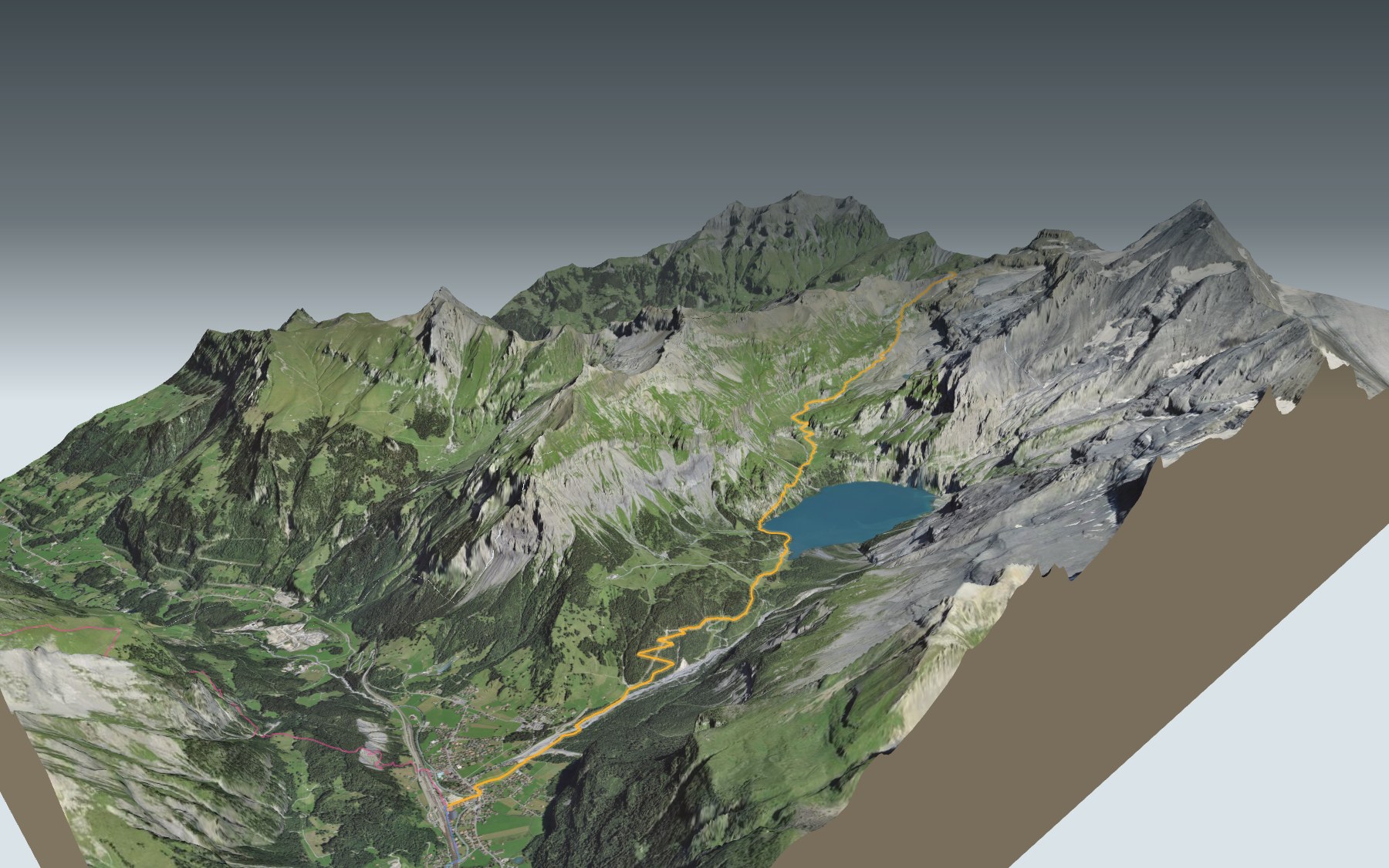
This is stage 13 of the Via Alpina: you start at Griesalp, in the Kiental, cross the Hohtürli pass at the foot of the Blüemlisalp, and drop down the other side to the Oeschinensee and on to Kandersteg. It's rated demanding for fitness and medium for technique.
The climb goes through the Bundalp pasture, then heads straight up to the pass, the highest point of the day. On the far side, the descent runs through Oberbärgli and Unterbärgli to the lakeshore, then down to the village. The elevation profile shows you where it climbs and where it plunges.
The 3D map also shows three other routes into Kandersteg, from Adelboden, Oey or Elsigbach: they come in from the west and go over neither the pass nor the lake. Their estimated times are in the list of starting points. The next day, from Kandersteg, you can carry on with Kandersteg → Selden, or further along the Via Alpina with Adelboden → Lenk.
At the finish is Kandersteg station, on the Lötschberg line. Check the next departures from Kandersteg and plan your day before you set off. Looking for more in the area? See all hikes in the Bernese Oberland.
The story of the trail
What happened where you are going to walk, chapter by chapter.
From the Kiental to the pass
You start at 1,410 m in Griesalp and finish at 1,171 m at Kandersteg station. In between: 17.3 km, 1,450 m of climbing and 1,700 m of descent. Allow 7 h 15 of walking in this direction and 7 h 35 the other way. To get up to Griesalp, the PostBus leaves from Reichenbach: between Tschingel and Griesalp it runs on the steepest stretch of the whole PostBus network.
The path first climbs to the Bundalp, where the Berghaus Bundalp, at km 2.7 and 1,840 m, sits right by the trail. After that the slope steepens all the way to the Hohtürli, at km 6.0, the highest point of the route at 2,793 m. Bring enough to drink, and go by the signposts and the conditions on the day.
The Hohtürli and its hut
The Hohtürli is the pass between the Kiental and the Oeschinen valley. It's a well-known crossing on the Bärentrek, the trail that runs from Meiringen to the Saanenland via the Kiental and Kandersteg. From the pass, the view reaches far out over the Swiss Plateau.
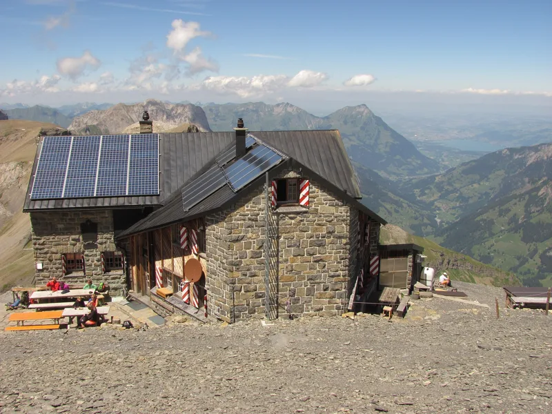
Close by, 141 m from the route, stands the Blüemlisalp hut of the Swiss Alpine Club. It dates from 1946-1947 and now sleeps 100; before it came the Frauenbalm hut in 1875 and the Hohtürli hut in 1894. It is staffed in July, August and September, and part of June and October.
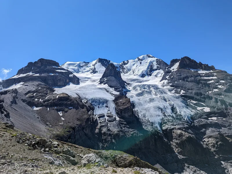
The Blüemlisalp, a cursed pasture
The pass opens at the foot of the Blüemlisalp massif, in the municipality of Kandersteg, with its four main summits: the Oeschinenhorn, the Blüemlisalphorn, the Weisse Frau and the Morgenhorn. Its name comes from a legend told in similar forms all over the Alps.
Long ago, there was a flowery pasture where the glacier lies today. Its owners, wasteful and godless, are said to have seen it turned into a wasteland of rock and ice as punishment. In the Kiental, the massif is also called « the Frau ». The present names were fixed in 1864 for the Dufour map, and the Blüemlisalphorn was first climbed on 27 August 1860.
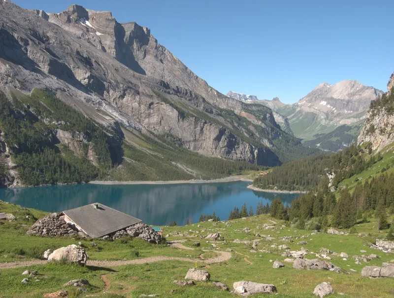
A lake born of rockfalls
The descent passes Oberbärgli, at km 9.7, then the Berghaus Unterbärgli, at km 10.5 and 1,804 m. Around km 11.7 the path reaches the shore of the Oeschinensee and follows it to the Berghaus Oeschinensee, at km 12.7, and the Berghotel Oeschinensee, at km 12.8.
The lake was created by several rockfalls from the flanks of the Fründenhorn and the Doldenhorn about 3,200 years ago: the debris formed a natural dam. That rock lets water through, so the lake drains underground, and its level changes a lot over the year. The water comes back up a few hundred metres lower down, in the Öschibach. Since 2007 the lake has been part of the Swiss Alps Jungfrau-Aletsch UNESCO World Heritage site.
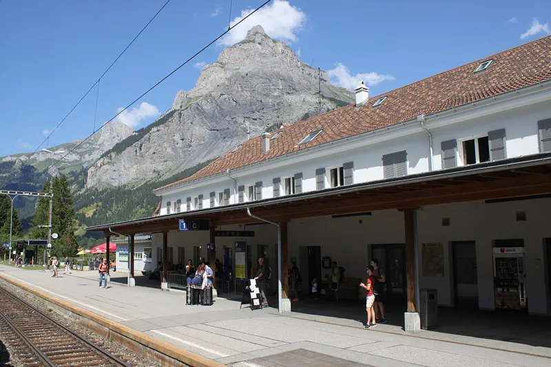
Kandersteg, at the foot of the passes
Kandersteg lived from its alpine pastures, from mule transport over the passes and, in the 17th and 18th centuries, from sulphur mined on the Oeschinenalp. Tourism came with the early days of mountaineering, from 1850: five hotels opened between 1855 and 1890, and there were nineteen by 1913.
Building the Lötschberg railway, from 1906 to 1913, swelled the population for a while. The Oeschinensee chairlift dates from 1948, and the international scout centre from 1923. At the end of the trail you catch the train at the station; further down the page are the next departures.
Every way to Kandersteg
4 starting points to reach Kandersteg. Pick yours: the 3D view shows it and “My day” recalculates.
Walking times without breaks. “Estimated” times are calculated on the terrain profile with a model fitted to the official stages; the shortest path may differ from the one on the yellow signposts: on the ground, follow the signs. Gradient: the steepest over 200 m of trail. Profiles share the same scale (length and altitude). Stations and car parks within 500 m of the start.
In pictures
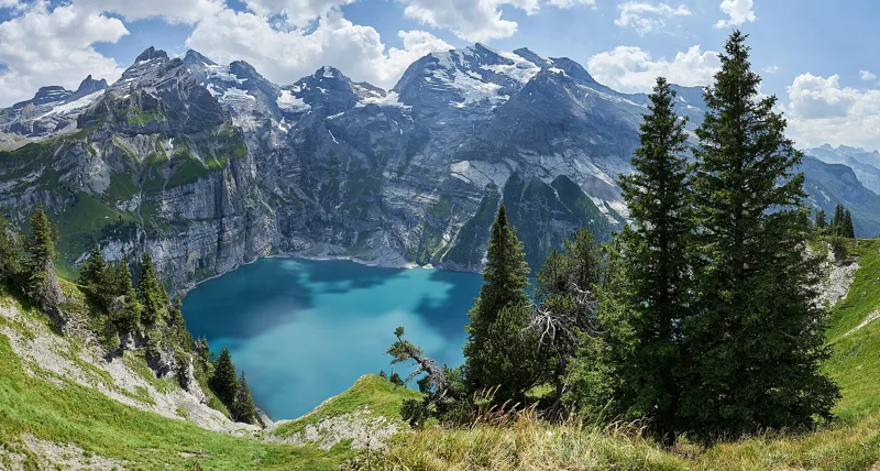
Panoramic view of the Oeschinensee with the Blüemlisalp, Fründenhorn and Doldenhorn, from the Heuberg
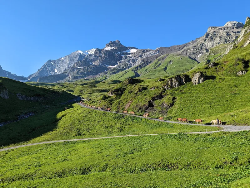
The Hohtürli pass, the Hohtürlihang and the Wildi Frau near the Blüemlisalp hut, seen from the Oberi Bundalp in the upper Kiental
From the Obere Bundalp in the Kiental, looking up the Hohtürlihang, with the Wildi Frau top left
The signpost on the Hohtürli: left to the Oeschinensee, right to the Bundalp in the Kiental
The south-east side of the Blüemlisalp hut, with Lake Thun and the Kiental behind
The Blüemlisalp Rothorn on the right; in the middle the Ufem Stock and its glacier; on the left the Hohtürli pass and the hut
The Oeschinensee seen from Underbärgli
The scar left by the Oeschinensee landslide
The Berghaus am Oeschinensee, a hotel next to the lake
A cow near the Oeschinensee, at an altitude of 1,575 m
Kandersteg railway station, with the Bire behind
Griesalp → Oeschinensee → Kandersteg: when to go
The bus runs up to the start every day from 29 May to 24 October 2027, according to the official timetable: that's the season to do this hike without a car. Here the sun clears the ridge late, and the latest time to set off ranges from 13:09 in June to 8:27 in December.
- Bus to the start
- off season
- no arrival found in the official timetable, read on 11/11/2026
- Sun at the start, mid-January
- from 9:55
- rises at 8:09, hidden by the ridge
- Leave by, for 7 h 15 of walking
- 8:53
- arrive 1 hour before sunset, at 17:08
| Month | Sun at the start | Leave by | In the sun, leaving at 9:00 | Bus |
|---|---|---|---|---|
| December | 11:30 → 16:42 | 8:27 | 26 % | off season |
| January | 9:55 → 17:08 | 8:53 | 33 % | off season |
| February | 9:29 → 17:53 | 9:38 | 81 % | off season |
“In the sun”: the share of the path in sunlight under a clear sky, with the terrain worked out point by point. The path climbs to 2,793 m: today's snow and frost are in the weather and My day.
- Bus to the start
- 3 of 92 days
- 5 to 6 buses a day
- first bus 8:12
- last 16:12 or 18:12
- Sun at the start, mid-April
- from 8:58
- rises at 6:42, hidden by the ridge
- Leave by, for 7 h 15 of walking
- 12:01
- arrive 1 hour before sunset, at 20:16
| Month | Sun at the start | Leave by | In the sun, leaving at 9:00 | Bus |
|---|---|---|---|---|
| March | 8:26 → 18:34 | 10:19 | 99 % | off season |
| April | 8:58 → 20:16 | 12:01 | 99 % | off season |
| May | 8:43 → 20:55 | 12:40 | 100 % | 3 of 31 days |
“In the sun”: the share of the path in sunlight under a clear sky, with the terrain worked out point by point. The path climbs to 2,793 m: today's snow and frost are in the weather and My day.
- Bus to the start
- every day
- 5 to 6 buses a day
- first bus 8:12
- last 16:12 or 18:12
- Sun at the start, mid-July
- from 8:51
- rises at 5:51, hidden by the ridge
- Leave by, for 7 h 15 of walking
- 13:04
- arrive 1 hour before sunset, at 21:19
| Month | Sun at the start | Leave by | In the sun, leaving at 9:00 | Bus |
|---|---|---|---|---|
| June | 8:43 → 21:24 | 13:09 | 100 % | every day |
| July | 8:51 → 21:19 | 13:04 | 100 % | every day |
| August | 8:57 → 20:40 | 12:25 | 100 % | every day |
“In the sun”: the share of the path in sunlight under a clear sky, with the terrain worked out point by point. The path climbs to 2,793 m: today's snow and frost are in the weather and My day.
- Bus to the start
- daily, 1 Sept to 24 Oct
- 5 to 6 buses a day
- first bus 8:12
- last 16:12 or 18:12
- Sun at the start, mid-October
- from 9:40
- rises at 7:46, hidden by the ridge
- Leave by, for 7 h 15 of walking
- 10:28
- arrive 1 hour before sunset, at 18:43
| Month | Sun at the start | Leave by | In the sun, leaving at 9:00 | Bus |
|---|---|---|---|---|
| September | 9:03 → 19:42 | 11:27 | 99 % | every day |
| October | 9:40 → 18:43 | 10:28 | 89 % | 24 of 31 days |
| November | 9:17 → 16:56 | 8:41 | 52 % | off season |
“In the sun”: the share of the path in sunlight under a clear sky, with the terrain worked out point by point. The path climbs to 2,793 m: today's snow and frost are in the weather and My day.
The next few days
Local forecast, updated every hour
Reading the forecast…
My day
Pick your day and start time: everything updates.
- Arrival at Kandersteg
- 15:45 7 h 15 of walking without breaks, starting at 08:30
The trail, kilometre by kilometre
From Griesalp
Places are listed under the kilometre where you pass them. Drag along the profile: the marker moves on the 3D view too.
- under 10 %
- 10 to 20 %
- 20 to 30 %
- over 30 %
- fountain or water point
- toilets
Around the trail (250 m): 18 restaurants, 1 café, 6 fountains and water points and 10 toilets. Estimated time: the official walking time spread by effort (1 km on the flat counts as 100 m of climbing), start time set in “My day”.
- under 10 %
- 10 to 20 %
- 20 to 30 %
- over 30 %
- fountain or water point
- toilets
Around the trail (250 m): 14 restaurants, 1 café, 4 fountains and water points and 5 toilets. Estimated time: the official walking time spread by effort (1 km on the flat counts as 100 m of climbing), start time set in “My day”.
- under 10 %
- 10 to 20 %
- 20 to 30 %
- over 30 %
- fountain or water point
- toilets
Around the trail (250 m): 19 restaurants, 1 café, 5 fountains and water points and 7 toilets. Estimated time: the official walking time spread by effort (1 km on the flat counts as 100 m of climbing), start time set in “My day”.
- under 10 %
- 10 to 20 %
- 20 to 30 %
- over 30 %
- fountain or water point
- toilets
Around the trail (250 m): 14 restaurants, 1 café, 3 fountains and water points and 4 toilets. Estimated time: the official walking time spread by effort (1 km on the flat counts as 100 m of climbing), start time set in “My day”.
Getting there and back
Back by public transport from the Kandersteg, Bahnhof stop
Next departures from Kandersteg, BahnhofReading the official timetable…
By car
From Griesalp
Careful, this is one way: public transport back arrives in Kandersteg, Bahnhof, not in Griesalp. Plan to get back to your car by public transport, or park at the finish and take public transport to the start.
- Kiental Griesalpopen-air · paid130 m from the start
- Tschingelopen-air · paid510 m from the start
- Car park open-air50 m from the start
Public car parks within 600 m of the start: prices and number of spaces may have changed, check the signs on site.
Careful, this is one way: public transport back arrives in Kandersteg, Bahnhof, not in Oey. Plan to get back to your car by public transport, or park at the finish and take public transport to the start.
- Sillerenbahnpaid60 m from the start
- Stop Mineralquelleor by public transport110 m from the start
The nearest car park and stop for this start. Check the signs on site for the price.
Careful, this is one way: public transport back arrives in Kandersteg, Bahnhof, not in Adelboden. Plan to get back to your car by public transport, or park at the finish and take public transport to the start.
- Marktplatz80 m from the start
- Stop Adelboden, Dorf Sillerenbahnor by public transport80 m from the start
The nearest car park and stop for this start. Check the signs on site for the price.
Careful, this is one way: public transport back arrives in Kandersteg, Bahnhof, not in Elsigbach. Plan to get back to your car by public transport, or park at the finish and take public transport to the start.
- Car parkpaid20 m from the start
- Stop Elsigbachor by public transport10 m from the start
The nearest car park and stop for this start. Check the signs on site for the price.
Questions people ask
How long is the hike from Griesalp to Kandersteg?
7 h 15 of walking (official time), in this direction, not counting breaks. The other way: 7 h 35.
Is it hard?
Official rating for this stage: fitness difficult, technique medium. It is 1,700 m of descent over 17.3 km.
Can I get back by public transport?
Yes. The Kandersteg, Bahnhof stop is at the finish. The next departures show live under “Getting there and back”.
Where can I eat on the way?
21 places to eat within 250 m of the trail, including Restaurant Berghaus, Rocky Grieshouse, Berghaus Bundalp. Where they are and their opening hours: below the profile.
Is there water and are there toilets on the way?
6 fountains and water points and 10 toilets within 250 m of the trail (survey of 25/10/2026).
Can I download the track?
Yes, as a GPX file for your watch or map app: “Download the track” button at the top of the page.
More hikes within 10 km
Official stages that pass within 10 km of this trail. Each card says whether its page is already up.
- © swisstopoKandersteg, Bahnhof, loop0 h 55Wageti-Rundweg4.0kmDistance30mAscent30mDescentTechnical easyFitness medium. Official waymarked stage
- © swisstopoKandersteg, Bahnhof, loop0 h 50Oeschigässli-Kander-Rundweg3.0kmDistance40mAscent40mDescentTechnical mediumFitness medium. Official waymarked stage
- © swisstopoKiental → Kandersteg6 h 30Lötschberg-Panoramaweg, stage 120.0kmDistance1,150mAscent950mDescentTechnical mediumFitness difficult. Official waymarked stage
- © swisstopoElsigenalp → Adelboden3 h 15Höhenweg Elsigenalp–Adelboden10.0kmDistance400mAscent840mDescentTechnical mediumFitness medium. Official waymarked stage
- © swisstopoSelden → Lauchernalp5 h 00Lötschberg-Panoramaweg, stage 311.0kmDistance1,300mAscent720mDescentTechnical mediumFitness difficult. Official waymarked stage
- © swisstopoAeschi bei Spiez → Saxeten6 h 10ViaBerna, stage 1217.0kmDistance1,200mAscent950mDescentTechnical mediumFitness difficult. Official waymarked stage