
Walking the Stoos ridge
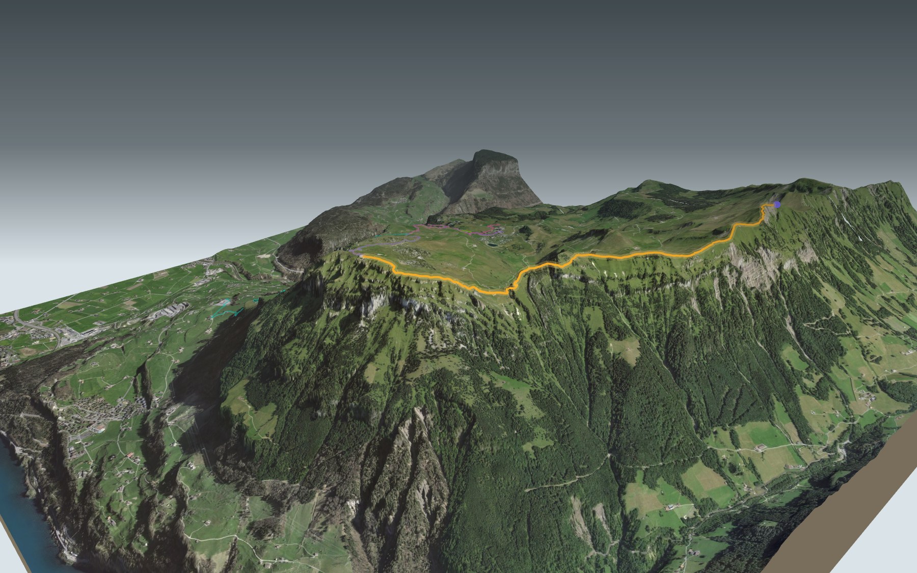
The Gratweg Stoos, also known as the Stoos Ridge hike, follows the crest from the Klingenstock to the Fronalpstock, above the car-free village of Stoos. One chairlift takes you up to the start, another brings you down from the finish. In between, you follow the ridge with Lake Lucerne far below. It is rated easy for fitness and medium for technique.
The path passes the Rot Turen, runs along the Nollen, passes below Huser Stock, then drops to Furggeli on a section cut into the rock and fitted with chains. The last climb, up to the Fronalpstock, is the steepest: the elevation profile shows you where.
Rather walk up? Start in the village of Stoos or at the Morschach valley station and climb straight to the Fronalpstock: each start has its own colour on the 3D map, and its estimated time is in the list of starting points.
At the top: the highest restaurant in the canton of Schwyz and a view over ten lakes. The chairlift takes you back to Stoos, where the steepest funicular in the world runs down to Schwyz. Check getting there and back and plan your day before you set off. Fancy something else nearby? All the hikes in Central Switzerland.
The story of the trail
What happened where you are going to walk, chapter by chapter.
A ridge between two chairlifts
You start at 1,926 m, at the Klingenstock chairlift station, and finish at 1,907 m, on the Fronalpstock. In between: 4.5 km, 380 m of climbing and 400 m of descent. Allow 1 h 50 of walking in this direction, 1 h 55 the other way.
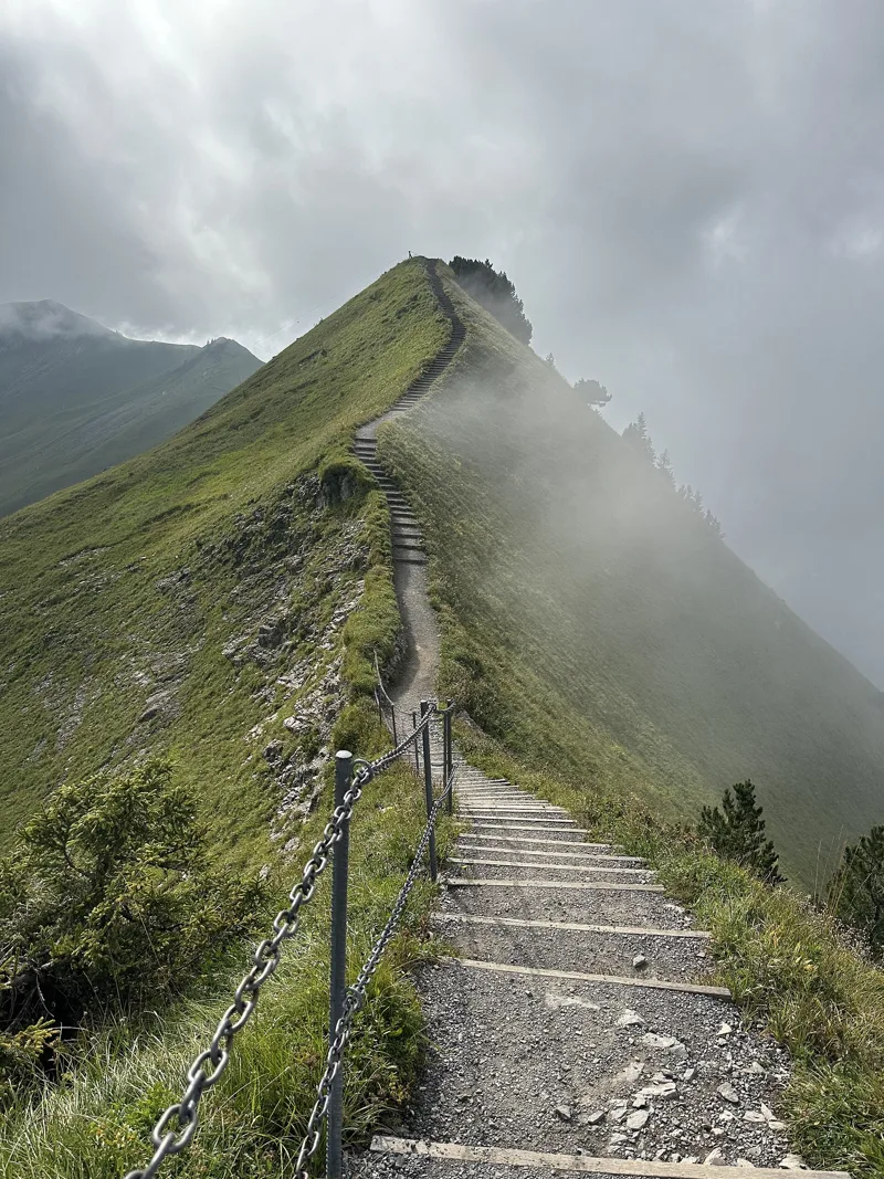
The mountain path is cut into the rock in places and secured with chains: you need to be sure-footed and free of vertigo. It is graded T3 on the SAC scale; wear good shoes with grippy soles. The chains are usually in place from early June to early November. On the day, follow the signposts and the current conditions.
Rot Turen, Nollen, Huser Stock
From the Klingenstock the path heads west, passes the Rot Turen and runs along the Nollen. The two Mythen peaks rise to your right; to your left you see first the Riemenstaldner Tal valley, then Lake Uri. Further on, the path passes below the summit of Huser Stock: you can climb up to it, or head straight down to Furggeli.
Next, a path cut into the rock and secured with chains zigzags down to Furggeli. The Furggeli hut is at km 3.2, at 1,731 m: the lowest point of the walk. What remains is the steepest climb, from Furggeli up to the summit of the Fronalpstock.
From summer pastures to ski resort
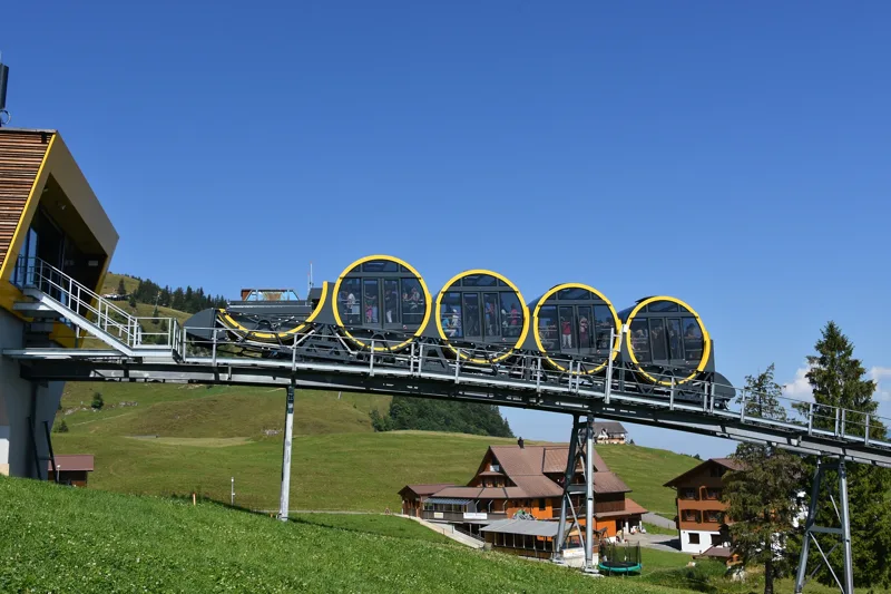
For centuries the Stoos pastures were summer grazing for the people of Arth, on the Fronalp, and of Schwyz. Tourism began in 1852 with an inn and a whey-cure house; guests often came from the hotels in Brunnen and Morschach. The Schlattli-Stoos funicular, opened in 1933, turned Stoos into a ski resort. The first ski lift on the Fronalpstock dates from 1939, the six-seat chairlift on the Klingenstock from 2007.
Today the car-free village is reached by the steepest funicular in the world. Swiss President Doris Leuthard inaugurated it in December 2017, and it opened to the public on 17 December. Thanks to automatic levelling, passengers always stay horizontal.
Orchids and folded rock
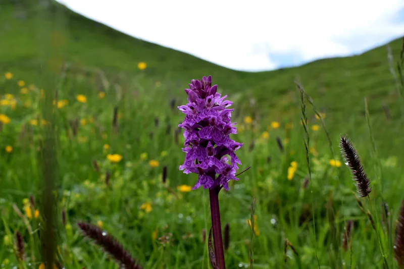
Between the Klingenstock and Huser Stock, the path crosses in places the dry meadows of the Nollen, listed in the federal inventory of dry grasslands of national importance. When they were surveyed, in 2010, botanists recorded orchids such as the black vanilla orchid and the globe orchid, as well as the orange lily and St Bruno's lily.
On the first part of the ridge, the geological map shows the Wang Formation, a dark grey-brown to blackish limestone that weathers pale. Further on, the path crosses, among others, Seewen limestone, from the Cretaceous, named after Seewen in the canton of Schwyz. Shortly before Huser Stock, you enter the Lake Lucerne landscape of national importance: Lake Uri lies in a valley shaped by the Reuss glacier, and the rock folds visible on both its shores are among the most striking in the Alps.
On the Fronalpstock, ten lakes
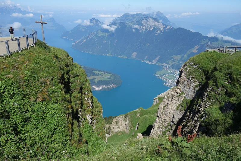
The path crosses the summit of the Fronalpstock, then reaches the chairlift station and the restaurant at 1,907 m: the highest restaurant in the canton, with its terrace. From up here the view takes in ten lakes, Pilatus, Rigi and Säntis, all the way to the High Alps, the Swiss Plateau and the Jura.
To get down, the covered chairlift takes you back to the village of Stoos, and the funicular down to Schwyz. Further down the page you'll find where to eat and how to get home.
Every way up to the top
5 starting points to reach Stoos (Fronalpstock). Pick yours: the 3D view shows it and “My day” recalculates.
Walking times without breaks. “Estimated” times are calculated on the terrain profile with a model fitted to the official stages; the shortest path may differ from the one on the yellow signposts: on the ground, follow the signs. Gradient: the steepest over 200 m of trail. Profiles share the same scale (length and altitude). Stations and car parks within 500 m of the start.
In pictures
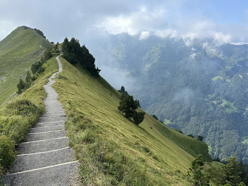
Stairs of the Gratweg Stoos (route 827) along the narrow crest of the Fronalpstock chain, with steep grass slopes on both sides
View from the Gratweg Stoos, on the west slope of the Rot Turen, towards Lake Uri
The Schwyz-Stoos funicular arriving at the top station
Flowers on the Stoos Ridge Trail
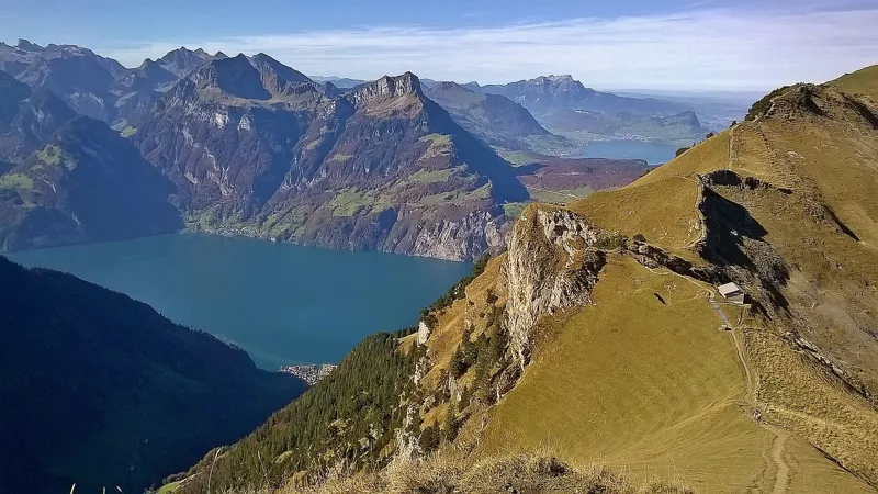
Lake Lucerne from the Fronalpstock, Stoos (SZ)
The pointed summit of Huser Stock above Stoos, seen from the west on the Gratweg Stoos ridge trail
Chain-secured stairs of the Gratweg Stoos climbing the crest of the Fronalpstock chain in drifting fog
View west from the summit area of Huser Stock along the Fronalpstock chain, with Lake Uri below
Gratweg Stoos at the Huser Stock: view south to the Chaiserstock chain
Wildflowers on the Stoos Ridge Trail
Fronalpstock, Stoos (SZ): top station and restaurant
What you see from the top
360° view from Klingenstock (1,926 m). 32 named peaks, including Hinter Tierberg, 37 km away. Swipe to look around.
Gratweg Stoos: when to go
Public transport serves the start every day from 19 December 2026 to 4 April 2027 and from 12 June to 10 October 2027 (and 7 other days), according to the official timetable: that's the season to do this hike without a car. The latest time to set off ranges from 18:32 in June to 13:47 in December.
- Public transport to the start
- daily, 19 Dec to 28 Feb
- 435 arrivals a day
- first arrival 9:07
- last 16:21
- Sun at the start, mid-January
- from 8:51
- rises at 8:07, hidden by the ridge
- Leave by, for 1 h 50 of walking
- 14:13
- arrive 1 hour before sunset, at 17:03
| Month | Sun at the start | Leave by | In the sun, leaving at 9:00 | Transport |
|---|---|---|---|---|
| December | 8:40 → 16:37 | 13:47 | 98 % | 13 of 31 days |
| January | 8:51 → 17:03 | 14:13 | 95 % | every day |
| February | 7:52 → 17:49 | 14:59 | 98 % | every day |
“In the sun”: the share of the path in sunlight under a clear sky, with the terrain worked out point by point. The path climbs to 1,926 m: today's snow and frost are in the weather and My day.
- Public transport to the start
- daily, 1 Mar to 4 Apr
- 435 arrivals a day
- first arrival 9:07
- last 16:21
- Sun at the start, mid-April
- from 6:54
- rises at 6:38, hidden by the ridge
- Leave by, for 1 h 50 of walking
- 17:23
- arrive 1 hour before sunset, at 20:13
| Month | Sun at the start | Leave by | In the sun, leaving at 9:00 | Transport |
|---|---|---|---|---|
| March | 6:50 → 18:30 | 15:40 | 100 % | every day |
| April | 6:54 → 20:13 | 17:23 | 98 % | 4 of 30 days |
| May | 6:00 → 20:53 | 18:03 | 100 % | off season |
“In the sun”: the share of the path in sunlight under a clear sky, with the terrain worked out point by point. The path climbs to 1,926 m: today's snow and frost are in the weather and My day.
- Public transport to the start
- daily, 12 Jun to 31 Aug
- 420 arrivals a day
- first arrival 9:07
- last 16:06
- Sun at the start, mid-July
- from 5:50
- rises at 5:46
- Leave by, for 1 h 50 of walking
- 18:27
- arrive 1 hour before sunset, at 21:17
| Month | Sun at the start | Leave by | In the sun, leaving at 9:00 | Transport |
|---|---|---|---|---|
| June | 5:34 → 21:22 | 18:32 | 100 % | 19 of 30 days |
| July | 5:50 → 21:17 | 18:27 | 100 % | every day |
| August | 6:29 → 20:37 | 17:47 | 98 % | every day |
“In the sun”: the share of the path in sunlight under a clear sky, with the terrain worked out point by point. The path climbs to 1,926 m: today's snow and frost are in the weather and My day.
- Public transport to the start
- daily, 1 Sept to 10 Oct
- and also 7 other days
- 420 arrivals a day
- first arrival 9:07
- last 16:06
- Sun at the start, mid-October
- from 8:01
- rises at 7:43, hidden by the ridge
- Leave by, for 1 h 50 of walking
- 15:49
- arrive 1 hour before sunset, at 18:39
| Month | Sun at the start | Leave by | In the sun, leaving at 9:00 | Transport |
|---|---|---|---|---|
| September | 7:19 → 19:38 | 16:48 | 98 % | every day |
| October | 8:01 → 18:39 | 15:49 | 98 % | 16 of 31 days |
| November | 8:04 → 16:51 | 14:01 | 98 % | 1 of 30 days |
“In the sun”: the share of the path in sunlight under a clear sky, with the terrain worked out point by point. The path climbs to 1,926 m: today's snow and frost are in the weather and My day.
The next few days
Local forecast, updated every hour
Reading the forecast…
My day
Pick your day and start time: everything updates.
- Arrival at Stoos (Fronalpstock)
- 10:20 1 h 50 of walking without breaks, starting at 08:30
The trail, kilometre by kilometre
From Stoos (Klingenstock)
Places are listed under the kilometre where you pass them. Drag along the profile: the marker moves on the 3D view too.
- under 10 %
- 10 to 20 %
- 20 to 30 %
- over 30 %
- fountain or water point
- toilets
Around the trail (250 m): 1 restaurant, 1 fountain or water point and 2 toilets. Estimated time: the official walking time spread by effort (1 km on the flat counts as 100 m of climbing), start time set in “My day”.
- under 10 %
- 10 to 20 %
- 20 to 30 %
- over 30 %
- fountain or water point
- toilets
Around the trail (250 m): 2 restaurants, 2 fountains and water points and 2 toilets. Estimated time: the official walking time spread by effort (1 km on the flat counts as 100 m of climbing), start time set in “My day”.
- under 10 %
- 10 to 20 %
- 20 to 30 %
- over 30 %
- fountain or water point
- toilets
Around the trail (250 m): 10 restaurants, 3 fountains and water points and 4 toilets. Estimated time: the official walking time spread by effort (1 km on the flat counts as 100 m of climbing), start time set in “My day”.
- under 10 %
- 10 to 20 %
- 20 to 30 %
- over 30 %
- fountain or water point
- toilets
Around the trail (250 m): 10 restaurants, 3 fountains and water points and 4 toilets. Estimated time: the official walking time spread by effort (1 km on the flat counts as 100 m of climbing), start time set in “My day”.
- under 10 %
- 10 to 20 %
- 20 to 30 %
- over 30 %
- fountain or water point
- toilets
Around the trail (250 m): 5 restaurants, 2 fountains and water points and 4 toilets. Estimated time: the official walking time spread by effort (1 km on the flat counts as 100 m of climbing), start time set in “My day”.
Getting there and back
Back by public transport from the Fronalpstock stop
Next departures from FronalpstockReading the official timetable…
By car
From Stoos (Klingenstock)
Careful, this is one way: public transport back arrives in Fronalpstock, not in Stoos (Klingenstock). Plan to get back to your car by public transport, or park at the finish and take public transport to the start.
Public car parks within 600 m of the start: prices and number of spaces may have changed, check the signs on site.
Careful, this is one way: public transport back arrives in Fronalpstock, not in Talstation Morschach. Plan to get back to your car by public transport, or park at the finish and take public transport to the start.
- Car parkpaid60 m from the start
- Stop Morschach Luftseilbahnor by public transport20 m from the start
The nearest car park and stop for this start. Check the signs on site for the price.
Careful, this is one way: public transport back arrives in Fronalpstock, not in Skilift Sternegg Talstation. Plan to get back to your car by public transport, or park at the finish and take public transport to the start.
- Station Stoos (Stoosbahn)or by public transport160 m from the start
The nearest car park and stop for this start. Check the signs on site for the price.
Careful, this is one way: public transport back arrives in Fronalpstock, not in Skilift Maggiweid Talstation. Plan to get back to your car by public transport, or park at the finish and take public transport to the start.
- Station Stoos (Stoosbahn)or by public transport150 m from the start
The nearest car park and stop for this start. Check the signs on site for the price.
Careful, this is one way: public transport back arrives in Fronalpstock, not in Stoos (Mettlen/Fronalpstock). Plan to get back to your car by public transport, or park at the finish and take public transport to the start.
- Station Stoos (Stoosbahn)or by public transport470 m from the start
The nearest car park and stop for this start. Check the signs on site for the price.
Questions people ask
How long is the hike from Stoos (Klingenstock) to Stoos (Fronalpstock)?
1 h 50 of walking (official time), in this direction, not counting breaks. The other way: 1 h 55.
Is it hard?
Official rating for this stage: fitness easy, technique medium. It is 400 m of descent over 4.5 km.
Can I get back by public transport?
Yes. The Fronalpstock stop is at the finish. The next departures show live under “Getting there and back”.
Where can I eat on the way?
3 places to eat within 250 m of the trail, including Furggeli-Hütte, Fronalpstock. Where they are and their opening hours: below the profile.
Is there water and are there toilets on the way?
1 fountain or water point and 2 toilets within 250 m of the trail (survey of 25/10/2026).
Can I download the track?
Yes, as a GPX file for your watch or map app: “Download the track” button at the top of the page.
More hikes within 10 km
Official stages that pass within 10 km of this trail. Each card says whether its page is already up.
- Sisikon → Brunnen2 h 40Weg der Schweiz, stage 48.0kmDistance480mAscent480mDescentTechnical easyFitness medium. Official waymarked stage
- Flüelen → Sisikon2 h 15Weg der Schweiz, stage 37.0kmDistance300mAscent300mDescentTechnical easyFitness easy. Official waymarked stage
- Schwyz → Muotathal3 h 30Pragelpass-Weg, stage 114.0kmDistance300mAscent220mDescentTechnical easyFitness medium. Official waymarked stage
- Luzern → Altdorf0 h 55ViaGottardo, stage 74.0kmDistance60mAscent40mDescentTechnical easyFitness easy. Official waymarked stage
- Schwyz → Stans8 h 00ViaJacobi, stage 629.0kmDistance880mAscent950mDescentTechnical mediumFitness difficult. Official waymarked stage
- Seelisberg (Rütli) → Bauen3 h 00Weg der Schweiz, stage 19.0kmDistance520mAscent520mDescentTechnical easyFitness medium. Official waymarked stage