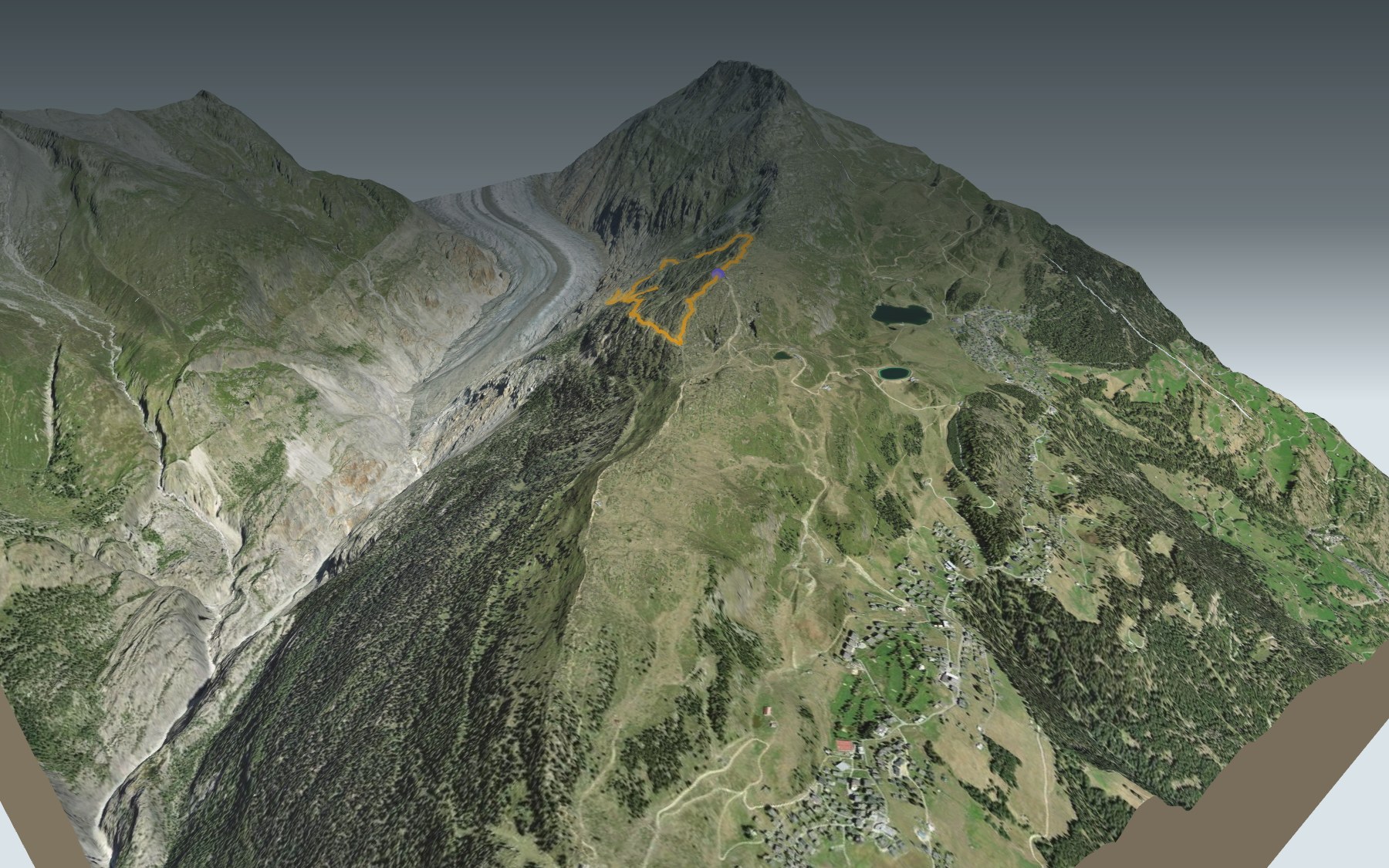

A loop around Moosfluh, facing the Aletsch Glacier
You start at Moosfluh, the top station of the gondola up from Riederalp, and you finish there too. In between, the loop drops towards the Great Aletsch Glacier, the longest stream of ice in the Alps, then climbs back up. It's rated medium for both fitness and technique.
Shortly after the start, the path reaches Alte Stafel, one of the viewpoints on the loop, then heads down towards the glacier. After the lowest point you pass near Chatzulecher, before climbing back up, skirting the Greicheralp and passing Biel. The elevation profile shows you the descent, then the climb.
You're walking inside the Swiss Alps Jungfrau-Aletsch UNESCO site and the Aletsch Forest federal game reserve. The Moosfluh slope is a large landslide: paths here were closed in 2016, so follow the signposts on the day. Further west, the stage from Belalp to the Riederfurka crosses the Massa gorge on a suspension bridge.
At the finish, the Buvette Moosfluh is near the station, and the gondola takes you back down to Riederalp if you'd rather not walk. Check the next departures and plan your day before you set off. Looking for more in the area? See all hikes in Valais.
The story of the trail
What happened where you are going to walk, chapter by chapter.
A loop facing the glacier
You start at Moosfluh, at 2,330 m, and come back to it. In between: 6.6 km, 500 m of climbing and 500 m of descent. Allow 2 h 35 of walking time, whichever way round you go.
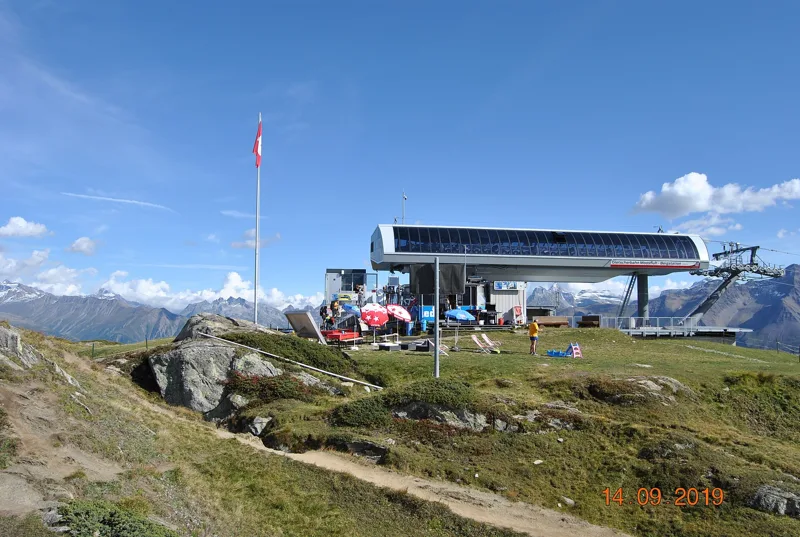
Moosfluh is the top station of the gondola up from Riederalp, one of the four viewpoints of the Aletsch Arena. Right at the start there's the Buvette Moosfluh: it's the only place to eat found near the path, so bring something to drink. On the way, follow the signposts and check the conditions on the day.
From Alte Stafel to the edge of the ice
The path first goes down to Alte Stafel, one of the viewpoints on the loop, with the glacier to the north and the Valais four-thousanders to the south. Then it drops towards the Great Aletsch Glacier.
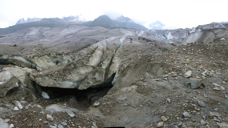
Halfway round, the path reaches its lowest point and comes closest to the glacier. It then passes near Chatzulecher, and the climb begins.
A slope on the move
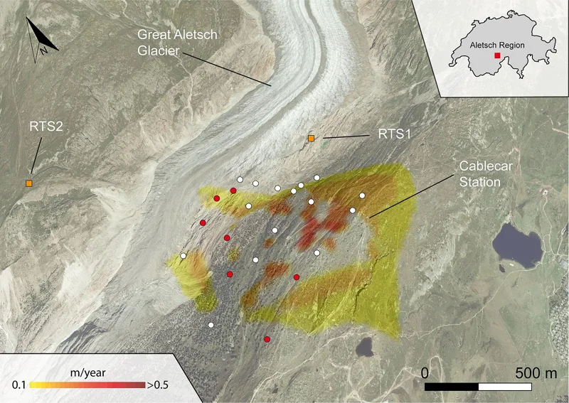
The Moosfluh slope is a large, deep-seated landslide. From the late 1970s it moved about 1 cm a year; in the mid-2000s it sped up to more than 10 cm a year, and in 2016 and 2017 it was exceptionally active. The cause: the retreat of the Aletsch Glacier, which used to press against the foot of the slope.
In September 2016, one measuring point recorded up to 170 mm of movement a day, and the paths in the sliding zone were closed from 22 September 2016. In the years before 2017, rockfalls at the foot of the slope became more and more frequent and intense. Underfoot there's mostly gneiss from the Aar massif and, on the lower part of the loop, moraine. Before you set off, check the state of the paths, and on the ground, follow the signposts.
The glacier, the forest and the red deer
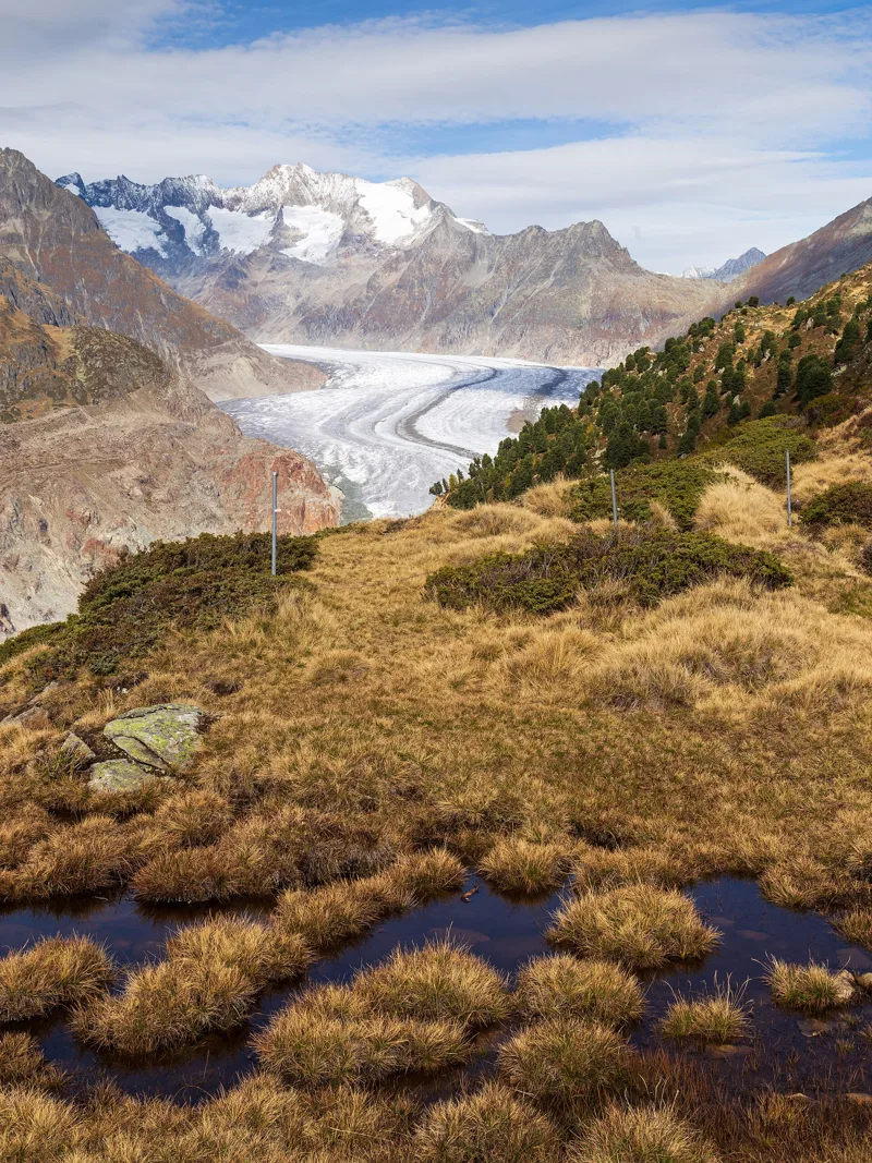
Below you lies the Great Aletsch Glacier, the longest stream of ice in the Alps. Its snout has been measured since 1870. From August 2014 to August 2024, every yearly measurement shows it retreating, except the one from September 2018 to September 2019. Since 2001 the glacier has been part of the Swiss Alps Jungfrau-Aletsch UNESCO site, the first World Heritage site in the Alps: almost the whole loop lies inside it, from just after the start to Biel.
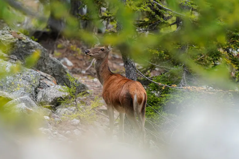
Most of the loop also runs through the Aletsch Forest federal game reserve, which stretches from the edge of the glacier up to the pastures above the treeline. It protects a varied habitat for wild mammals and birds, but there are too many red deer: from 1 October to 30 November, between Bitsch and the summit of the Sparrhorn, extra red deer culls are carried out on top of the regular hunt.
Back along the Greicheralp
After Chatzulecher, the path climbs back up, skirts the Greicheralp, passes Biel and brings you back to Moosfluh, where you started.
To get down to Riederalp, take the gondola or carry on on foot. Further down this page: the next departures.
In pictures
View of the Aletsch Glacier between Hohfluh and Moosfluh
Top station of the Moosfluh glacier cable car
Sunrise over the Bettmerhorn, seen from Moosfluh
Glacier mouth near the Katzenlöcher
Ground deformation speed in the Moosfluh area, observed by satellite from August to November 2016
The Aletsch Forest above the Aletsch Glacier, with the Wannenhörner behind
Old Swiss stone pine in the Aletsch Forest
Wild female red deer in the Aletsch Forest Nature Reserve
Chamois in the Aletsch Forest
European crested tit in the Aletsch Forest Nature Reserve in autumn
The Aletsch Glacier and Forest seen from the Moränenweg in 2017
Aletschgletscher Aussichtsweg: when to go
Public transport serves the start every day from 5 December 2026 to 3 April 2027 and from 5 June to 24 October 2027, according to the official timetable: that's the season to do this loop without a car. The latest time to set off ranges from 17:47 in June to 13:06 in December.
- Public transport to the start
- daily, 5 Dec to 28 Feb
- 450 arrivals a day
- first arrival 9:10
- last 16:39
- Sun at the start, mid-January
- from 8:27
- rises at 8:07, hidden by the ridge
- Leave by, for 2 h 35 of walking
- 13:32
- arrive 1 hour before sunset, at 17:07
| Month | Sun at the start | Leave by | In the sun, leaving at 9:00 | Transport |
|---|---|---|---|---|
| December | 8:22 → 16:41 | 13:06 | 32 % | 27 of 31 days |
| January | 8:27 → 17:07 | 13:32 | 30 % | every day |
| February | 7:43 → 17:52 | 14:17 | 35 % | every day |
“In the sun”: the share of the path in sunlight under a clear sky, with the terrain worked out point by point. The path climbs to 2,332 m: today's snow and frost are in the weather and My day.
- Public transport to the start
- daily, 1 Mar to 3 Apr
- 450 arrivals a day
- first arrival 8:40 or 9:10
- last 16:09 or 16:39
- Sun at the start, mid-April
- from 6:57
- rises at 6:41, hidden by the ridge
- Leave by, for 2 h 35 of walking
- 16:40
- arrive 1 hour before sunset, at 20:15
| Month | Sun at the start | Leave by | In the sun, leaving at 9:00 | Transport |
|---|---|---|---|---|
| March | 6:55 → 18:33 | 14:58 | 81 % | every day |
| April | 6:57 → 20:15 | 16:40 | 90 % | 3 of 30 days |
| May | 6:08 → 20:54 | 17:19 | 100 % | off season |
“In the sun”: the share of the path in sunlight under a clear sky, with the terrain worked out point by point. The path climbs to 2,332 m: today's snow and frost are in the weather and My day.
- Public transport to the start
- daily, 5 Jun to 31 Aug
- 480 arrivals a day
- first arrival 8:40
- last 16:39
- Sun at the start, mid-July
- from 6:14
- rises at 5:50, hidden by the ridge
- Leave by, for 2 h 35 of walking
- 17:42
- arrive 1 hour before sunset, at 21:17
| Month | Sun at the start | Leave by | In the sun, leaving at 9:00 | Transport |
|---|---|---|---|---|
| June | 6:05 → 21:22 | 17:47 | 100 % | 26 of 30 days |
| July | 6:14 → 21:17 | 17:42 | 100 % | every day |
| August | 6:34 → 20:38 | 17:03 | 100 % | every day |
“In the sun”: the share of the path in sunlight under a clear sky, with the terrain worked out point by point. The path climbs to 2,332 m: today's snow and frost are in the weather and My day.
- Public transport to the start
- daily, 1 Sept to 24 Oct
- 480 arrivals a day
- first arrival 8:40
- last 16:39
- Sun at the start, mid-October
- from 7:57
- rises at 7:45, hidden by the ridge
- Leave by, for 2 h 35 of walking
- 15:07
- arrive 1 hour before sunset, at 18:42
| Month | Sun at the start | Leave by | In the sun, leaving at 9:00 | Transport |
|---|---|---|---|---|
| September | 7:22 → 19:41 | 16:06 | 70 % | every day |
| October | 7:57 → 18:42 | 15:07 | 35 % | 24 of 31 days |
| November | 7:51 → 16:56 | 13:21 | 33 % | off season |
“In the sun”: the share of the path in sunlight under a clear sky, with the terrain worked out point by point. The path climbs to 2,332 m: today's snow and frost are in the weather and My day.
The next few days
Local forecast, updated every hour
Reading the forecast…
My day
Pick your day and start time: everything updates.
- Arrival at Riederalp, Moosfluh
- 11:05 2 h 35 of walking without breaks, starting at 08:30
The trail, kilometre by kilometre
Places are listed under the kilometre where you pass them. Drag along the profile: the marker moves on the 3D view too.
- under 10 %
- 10 to 20 %
- 20 to 30 %
- over 30 %
- fountain or water point
- toilets
Around the trail (250 m): 1 toilet. Estimated time: the official walking time spread by effort (1 km on the flat counts as 100 m of climbing), start time set in “My day”.
Getting there and back
Back by public transport from the Moosfluh stop
Next departures from MoosfluhReading the official timetable…
By car
Park in Riederalp, Moosfluh. It's a loop: you walk back to where you started, and so to your car.
Public car parks within 600 m of the start: prices and number of spaces may have changed, check the signs on site.
Questions people ask
How long does the loop from Riederalp, Moosfluh take?
2 h 35 of walking (official time), in this direction, not counting breaks. The other way: 2 h 35.
Is it hard?
Official rating for this stage: fitness medium, technique medium. It is 500 m of climbing over 6.6 km.
Can I get back by public transport?
Yes. The Moosfluh stop is at the finish. The next departures show live under “Getting there and back”.
Is there water and are there toilets on the way?
0 fountains and water points and 1 toilet within 250 m of the trail (survey of 25/10/2026).
Can I download the track?
Yes, as a GPX file for your watch or map app: “Download the track” button at the top of the page.
More hikes within 10 km
Official stages that pass within 10 km of this trail. Each card says whether its page is already up.
- © swisstopoRiederalp, Riederfurka → Märjelensee4 h 00Aletsch Panoramaweg, stage 211.0kmDistance820mAscent500mDescentTechnical mediumFitness medium. Official waymarked stage
- © swisstopoMärjelensee → Bellwald3 h 15Aletsch Panoramaweg, stage 39.0kmDistance340mAscent1,150mDescentTechnical mediumFitness difficult. Official waymarked stage
- © swisstopoFiesch → Fieschertal0 h 40Wysswasser-Weg3.0kmDistance70mAscent10mDescentTechnical mediumFitness difficult. Official waymarked stage
- © swisstopoBitsch → Lalden2 h 25Rotten-Weg Bitsch–Lalden10.0kmDistance20mAscent60mDescentTechnical mediumFitness difficult. Official waymarked stage
- © swisstopoAusserberg → Brig5 h 00Walliser Sonnenweg, stage 417.0kmDistance540mAscent880mDescentTechnical easyFitness medium. Official waymarked stage
- © swisstopoBinn → Rosswald6 h 15Alpenpässe-Weg, stage 1617.0kmDistance1,300mAscent900mDescentTechnical mediumFitness difficult. Official waymarked stage