
From First to Rosenlaui over the Grosse Scheidegg
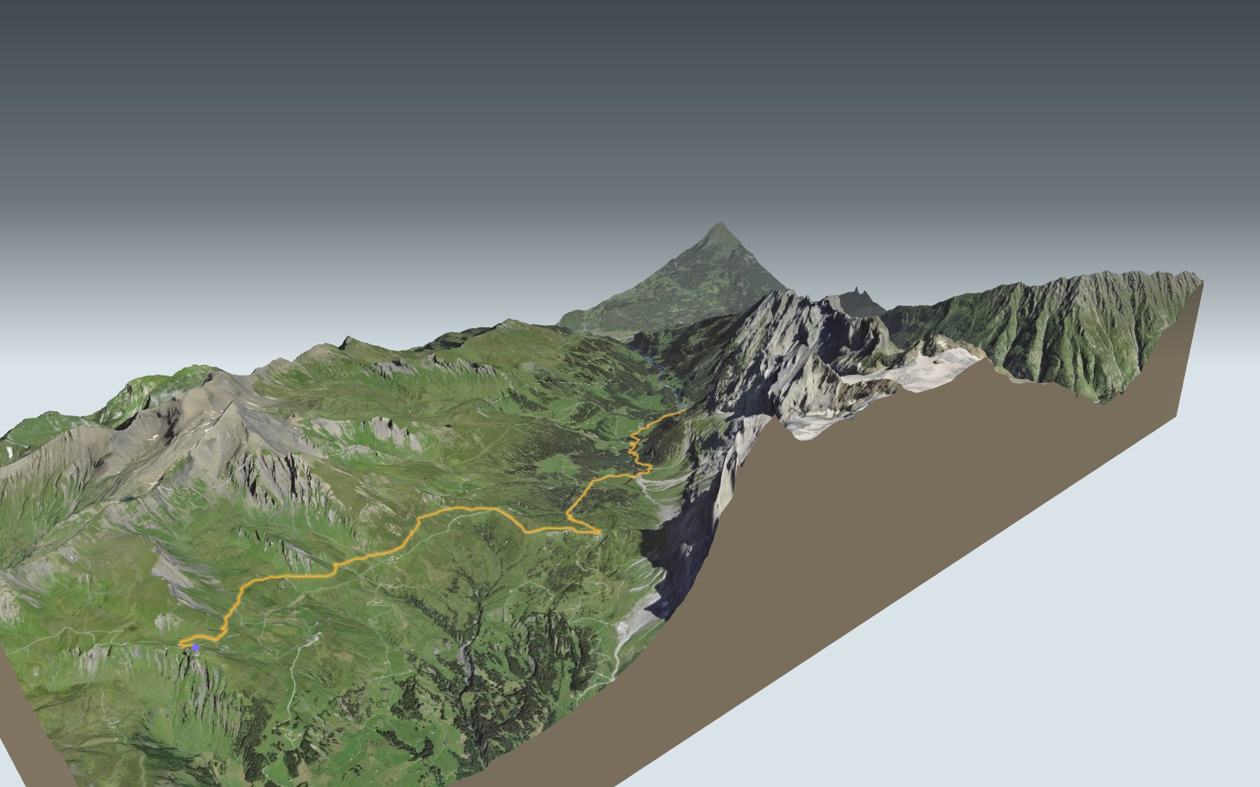
A classic Oberland crossing: you start at First, high above Grindelwald, walk over to the Grosse Scheidegg pass at the foot of the Wetterhorn, then head down the Reichenbach valley to Rosenlaui. This is stage 16 of the ViaBerna, in its official direction. It's rated difficult for fitness and medium for technique, and most of it is downhill.
You ride up to First on the Firstbahn gondola from Grindelwald. The path first drops towards Distelboden, passes the alpine huts of Grindel-Oberläger, climbs a little to Gratschärem, then reaches the pass. After that comes the long descent via Schwarzwaldalp, along the Rychenbach stream. The elevation profile shows you where it climbs again and where the descent gets steeper.
Would you rather walk up to Rosenlaui from the valley? Start from Reichenbachfall or Unterwasser: each starting point has its own colour in the 3D view and an estimated time under all starting points. The ViaBerna stage just before this one ends at First: it's the crossing from Schynige Platte to First.
At the finish you'll find the Hotel Rosenlaui, which has taken in guests since 1771, and the glacier gorge close by. Check the next departures from Rosenlaui and plan your day before you set off. Looking for more in the area? See all hikes in the Bernese Oberland, including the Eiger Trail.
The story of the trail
What happened where you are going to walk, chapter by chapter.
From First to the pass, along a balcony
You start at 2,166 m at First and finish at 1,326 m in Rosenlaui. In between: 12.6 km, 160 m of climbing and 1,000 m of descent. Allow 3 h 20 of walking time in this direction, and 4 h 15 the other way, uphill. The first lift to First, a two-seater chairlift, opened in 1947; the current gondola, with stops at Bort and Schreckfeld, dates from 1991.
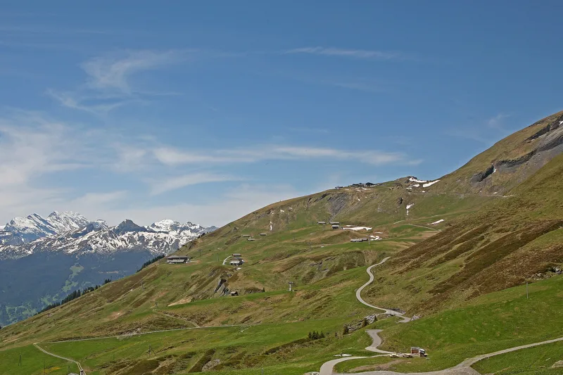
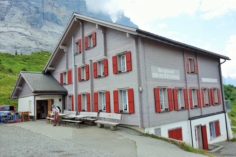
The path first drops towards Distelboden, passes the alpine huts of Grindel-Oberläger, then climbs a little. At Gratschärem the view opens up to the east, and the Kuhmatten Schärm shelter stands right by the path. At the pass, the Berghotel Grosse Scheidegg is the first place to eat after First; the next one is at Schwarzwaldalp. On the way, follow the signposts and check the conditions on the day.
An old crossing between two valleys
The Grosse Scheidegg links Grindelwald with the Hasli valley. It began as a route for the local economy, connecting the cattle and dairy farming of the Lütschine valleys with the export route to Italy over the Grimsel. On the Hasli side, along the old mule track over the pass, part of which still survives, the first inns opened in the late 18th century. Travel writing and engravings made them famous around the world.
With the arrival of tourism, a visit to the Grindelwald valleys became a must on any tour of Switzerland: travellers crossed the Wengernalp, then came down past the alpine huts to the Rosenlaui baths and Meiringen. In 1893 the Wengernalp Railway put an end to this classic Bernese Oberland tour. The Grosse Scheidegg itself saw little development: only a road for goods made a postbus line possible, to the top of the pass in 1966 and through to the Rosenlaui valley since 1979.
Below the Wetterhorn wall
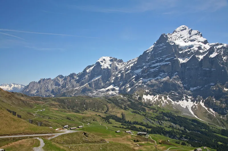
At the pass, the Wetterhorn wall rises almost vertically. You can clearly see the Gutz glacier on its flank. In 1996, 220,000 m³ of ice broke off and thundered down, until the ice lay across part of the Grosse Scheidegg. Since then the glacier has been monitored constantly.
Bilberries and dwarf juniper line the path, and streams cross it again and again. Underfoot, between Gratschärem and the way down to Schwarzwaldalp, the geological map shows mostly Jurassic clay and marl shales, dated by their ammonites. Around Schwarzwaldalp there is iron-rich sandstone, with fossil gastropods, crinoids and bivalves. Just past the pass, the map also marks an area where the ground is slowly sinking.
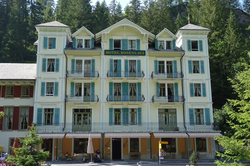
Rosenlaui, from spa to hotel
It all began in 1771. While cutting wood at Rosenlaui, a local man, Andreas von Bergen, found a healing spring; he bought the pasture and set up a bath there. The baths were licensed in 1788; in the 19th century an inn and a spa house were added. In 1912, ground movements almost completely buried the sulphur spring.
The hotel has taken in guests since 1771. Its oldest part was built in 1862, after a fire; the Belle Époque building, with the lounges and the restaurant, dates from 1905. Some rooms still have the furniture and comfort of 1861 and 1905, with no running water. Since the early 20th century a road has linked Rosenlaui with the Hasli valley; it was later extended up to the Grosse Scheidegg.
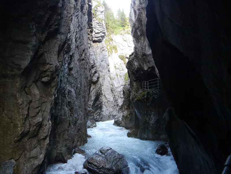
The gorge, then the finish
After the pass, the path drops through the pastures to Schwarzwaldalp, then follows the Rychenbach through moss-covered forest, passing Broch. Above the valley rise the jagged walls of the Engelhörner, which draw many mountaineers.
Just before the finish, the path passes close to the Rosenlaui glacier gorge. In summer 1901, Meiringen hotelier Kaspar Brog bought the Rosenlaui properties and had the gorge opened up: the work, led by Tyrolean contractor Johann Berti, took 9,000 blasting charges in the limestone. The gorge opened on 6 June 1903, when 38 visitors paid one franc each to get in. His descendants extended the path in the winter of 1930-1931. At Rosenlaui, the bus heads down to Meiringen or up to Grindelwald; further down this page: the next departures.
Every way to Rosenlaui
3 starting points to reach Rosenlaui. Pick yours: the 3D view shows it and “My day” recalculates.
Walking times without breaks. “Estimated” times are calculated on the terrain profile with a model fitted to the official stages; the shortest path may differ from the one on the yellow signposts: on the ground, follow the signs. Gradient: the steepest over 200 m of trail. Profiles share the same scale (length and altitude). Stations and car parks within 500 m of the start.
In pictures
The hiking trail from the First mountain station to the Grosse Scheidegg pass
The Cliff Walk at Grindelwald-First, looking towards the Gross Fiescherhorn and the Eiger
The Grosse Scheidegg and the Wetterhorn
From the Grosse Scheidegg, looking at the Eiger North Face and the surrounding mountains
The Berghotel Grosse Scheidegg
The Rosenlaui valley seen from the Grosse Scheidegg
Schwarzwaldalp in the Reichenbach valley in summer
The Engelhörner seen from Schwarzwaldalp
The Hotel Rosenlaui in 2018
The spring of the Rosenlaui baths, 1771
The Rosenlaui Gorge near Rosenlaui
Grindelwald, First → Rosenlaui: when to go
Public transport serves the start every day from 28 November 2026 to 24 October 2027, according to the official timetable. The latest time to set off ranges from 17:03 in June to 12:20 in December.
- Public transport to the start
- every day
- 405 to 495 arrivals a day
- first arrival 8:25 or 9:25
- last 16:09 or 16:39
- Sun at the start, mid-January
- from 9:08
- rises at 8:08, hidden by the ridge
- Leave by, for 3 h 20 of walking
- 12:46
- arrive 1 hour before sunset, at 17:06
| Month | Sun at the start | Leave by | In the sun, leaving at 9:00 | Transport |
|---|---|---|---|---|
| December | 9:01 → 16:40 | 12:20 | 5 % | every day |
| January | 9:08 → 17:06 | 12:46 | 0 % | every day |
| February | 8:52 → 17:52 | 13:32 | 23 % | every day |
“In the sun”: the share of the path in sunlight under a clear sky, with the terrain worked out point by point. The path climbs to 2,166 m: today's snow and frost are in the weather and My day.
- Public transport to the start
- every day
- 480 to 570 arrivals a day
- first arrival 8:25
- last 16:24, 16:39 or 17:54
- Sun at the start, mid-April
- from 6:59
- rises at 6:41, hidden by the ridge
- Leave by, for 3 h 20 of walking
- 15:55
- arrive 1 hour before sunset, at 20:15
| Month | Sun at the start | Leave by | In the sun, leaving at 9:00 | Transport |
|---|---|---|---|---|
| March | 7:27 → 18:33 | 14:13 | 92 % | every day |
| April | 6:59 → 20:15 | 15:55 | 100 % | every day |
| May | 6:12 → 20:55 | 16:35 | 100 % | every day |
“In the sun”: the share of the path in sunlight under a clear sky, with the terrain worked out point by point. The path climbs to 2,166 m: today's snow and frost are in the weather and My day.
- Public transport to the start
- every day
- 570 arrivals a day
- first arrival 8:25
- last 17:54
- Sun at the start, mid-July
- from 6:13
- rises at 5:49, hidden by the ridge
- Leave by, for 3 h 20 of walking
- 16:58
- arrive 1 hour before sunset, at 21:18
| Month | Sun at the start | Leave by | In the sun, leaving at 9:00 | Transport |
|---|---|---|---|---|
| June | 6:04 → 21:23 | 17:03 | 100 % | every day |
| July | 6:13 → 21:18 | 16:58 | 100 % | every day |
| August | 6:36 → 20:39 | 16:19 | 100 % | every day |
“In the sun”: the share of the path in sunlight under a clear sky, with the terrain worked out point by point. The path climbs to 2,166 m: today's snow and frost are in the weather and My day.
- Public transport to the start
- daily, 1 Sept to 24 Oct
- and also 28 November, 29 November and 30 November
- 405 to 570 arrivals a day
- first arrival 8:25 or 9:25
- last 16:09, 16:54 or 17:54
- Sun at the start, mid-October
- from 9:19
- rises at 7:45, hidden by the ridge
- Leave by, for 3 h 20 of walking
- 14:22
- arrive 1 hour before sunset, at 18:42
| Month | Sun at the start | Leave by | In the sun, leaving at 9:00 | Transport |
|---|---|---|---|---|
| September | 7:59 → 19:41 | 15:21 | 90 % | every day |
| October | 9:19 → 18:42 | 14:22 | 44 % | 24 of 31 days |
| November | 8:36 → 16:55 | 12:35 | 21 % | 3 of 30 days |
“In the sun”: the share of the path in sunlight under a clear sky, with the terrain worked out point by point. The path climbs to 2,166 m: today's snow and frost are in the weather and My day.
The next few days
Local forecast, updated every hour
Reading the forecast…
My day
Pick your day and start time: everything updates.
- Arrival at Rosenlaui
- 11:50 3 h 20 of walking without breaks, starting at 08:30
The trail, kilometre by kilometre
From Grindelwald, First
Places are listed under the kilometre where you pass them. Drag along the profile: the marker moves on the 3D view too.
- under 10 %
- 10 to 20 %
- 20 to 30 %
- over 30 %
- fountain or water point
- toilets
Around the trail (250 m): 3 restaurants and 5 fountains and water points. Estimated time: the official walking time spread by effort (1 km on the flat counts as 100 m of climbing), start time set in “My day”.
- under 10 %
- 10 to 20 %
- 20 to 30 %
- over 30 %
- fountain or water point
- toilets
Around the trail (250 m): 3 restaurants, 5 fountains and water points and 1 toilet. Estimated time: the official walking time spread by effort (1 km on the flat counts as 100 m of climbing), start time set in “My day”.
- under 10 %
- 10 to 20 %
- 20 to 30 %
- over 30 %
- fountain or water point
- toilets
Around the trail (250 m): 7 restaurants, 8 fountains and water points and 4 toilets. Estimated time: the official walking time spread by effort (1 km on the flat counts as 100 m of climbing), start time set in “My day”.
Getting there and back
Back by public transport from the Rosenlaui, Hotel stop
Next departures from Rosenlaui, HotelReading the official timetable…
By car
From Grindelwald, First
Careful, this is one way: public transport back arrives in Rosenlaui, Hotel, not in Grindelwald, First. Plan to get back to your car by public transport, or park at the finish and take public transport to the start.
Public car parks within 600 m of the start: prices and number of spaces may have changed, check the signs on site.
Careful, this is one way: public transport back arrives in Rosenlaui, Hotel, not in Reichenbachfall. Plan to get back to your car by public transport, or park at the finish and take public transport to the start.
- Station Reichenbachfallor by public transport0 m from the start
The nearest car park and stop for this start. Check the signs on site for the price.
Careful, this is one way: public transport back arrives in Rosenlaui, Hotel, not in Unterwasser. Plan to get back to your car by public transport, or park at the finish and take public transport to the start.
- Station Unterwasseror by public transport0 m from the start
The nearest car park and stop for this start. Check the signs on site for the price.
Questions people ask
How long is the hike from Grindelwald, First to Rosenlaui?
3 h 20 of walking (official time), in this direction, not counting breaks. The other way: 4 h 15.
Is it hard?
Official rating for this stage: fitness difficult, technique medium. It is 1,000 m of descent over 12.6 km.
Can I get back by public transport?
Yes. The Rosenlaui, Hotel stop is at the finish. The next departures show live under “Getting there and back”.
Where can I eat on the way?
3 places to eat within 250 m of the trail, including Berggasthaus First, Schwarzwaldalp. Where they are and their opening hours: below the profile.
Is there water and are there toilets on the way?
5 fountains and water points and 0 toilets within 250 m of the trail (survey of 25/10/2026).
Can I download the track?
Yes, as a GPX file for your watch or map app: “Download the track” button at the top of the page.
More hikes within 10 km
Official stages that pass within 10 km of this trail. Each card says whether its page is already up.
- © swisstopoMeiringen → Grindelwald8 h 00Via Alpina, stage 1023.0kmDistance1,550mAscent1,100mDescentTechnical mediumFitness difficult. Official waymarked stage
- © swisstopoRosenlaui → Hasliberg, Reuti3 h 40ViaBerna, stage 1711.0kmDistance520mAscent800mDescentTechnical mediumFitness medium. Official waymarked stage
- © swisstopoRosenlaui (Chaltenbrunnen) → Zwirgi5 h 00Chaltenbrunnen-Hochmoorweg14.0kmDistance880mAscent1,100mDescentTechnical mediumFitness difficult. Official waymarked stage
- © swisstopoAxalp, Sportbahnen, loop2 h 05Axalp-Schnitzlerweg6.0kmDistance400mAscent400mDescentTechnical mediumFitness easy. Official waymarked stage
- Engstlenalp → Meiringen7 h 00Via Alpina, stage 922.0kmDistance740mAscent1,950mDescentTechnical mediumFitness difficult. Official waymarked stage
- Engstlenalp → Guttannen6 h 40ViaSbrinz, stage 323.0kmDistance680mAscent1,450mDescentTechnical mediumFitness difficult. Official waymarked stage