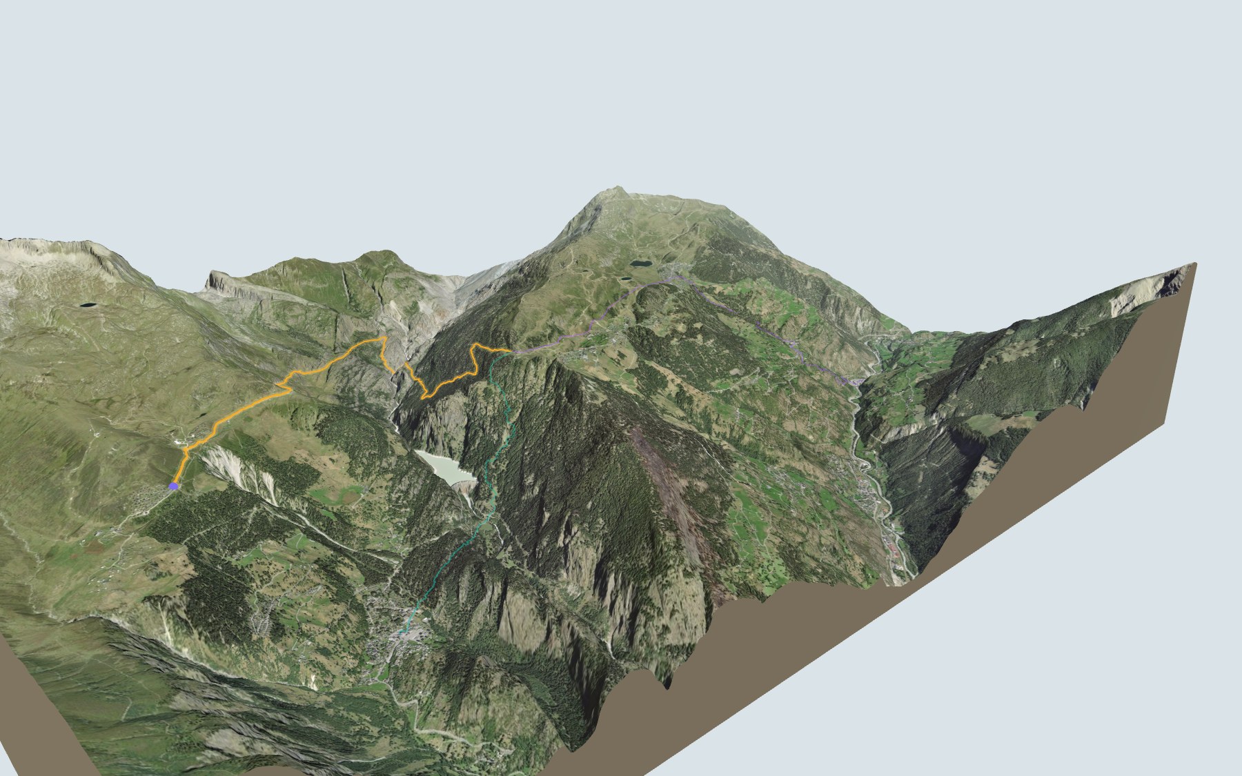

From Belalp to Riederfurka over the suspension bridge
A hike in two halves: you start at Belalp, head down to the Massa gorge, then climb back up through the Aletsch Forest to Riederfurka. This is the first stage of the Aletsch Panoramaweg. SwitzerlandMobility rates it medium, for both fitness and technique.
After the Hotel Belalp, the path drops via Oberaletsch to the Massa and crosses it on a suspension bridge. It then climbs back up past the Grünsee and through the Teiffe Wald. The elevation profile shows you both halves: the descent, then the climb.
Rather start from the valley? Three other starting points, lower down, climb up to Riederfurka: each has its own colour in the 3D view and an estimated time under all starting points. For another suspension bridge in Valais, try the Randa Hängebrückenweg.
At the finish, the Villa Cassel, once the summer home of a London banker and now a Pro Natura centre, stands five minutes above Riederfurka. Check the next departures and plan your day before you set off. Looking for more in the area? See all hikes in Valais.
The story of the trail
What happened where you are going to walk, chapter by chapter.
Down to the Massa, then back up
You start at 2,096 m at Belalp and finish at 2,056 m at Riederfurka. In between: 9.9 km, plus 700 m of climbing and 740 m of descent according to SwitzerlandMobility, which gives 3 h 45 of walking time in either direction. The path first rises to 2,133 m, near the Hotel Belalp, then drops via Oberaletsch to the Massa, which it crosses on a suspension bridge. It then climbs back up past the Grünsee and through the Teiffe Wald to Riederfurka.
At the start you'll find the Restaurant Bergstation, then you pass the Hotel Belalp shortly after. The next place to eat is Riederfurka, at the finish, so bring something to drink. On the way, follow the signposts and check the conditions on the day.
Belalp, Tyndall's summer retreat
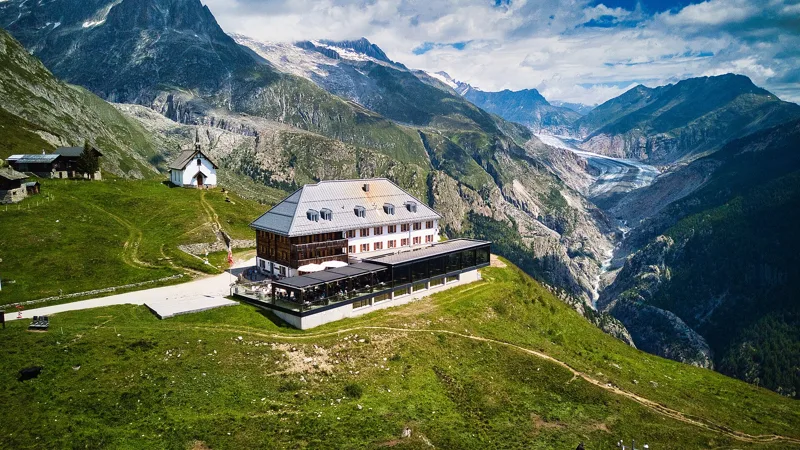
The Hotel Belalp was built in 1856/57, on the Aletschbord. For many years Belalp was also where physicist John Tyndall spent his summers. He was born in Ireland in 1820 and taught at the Royal Institution in London. He studied, among other things, how glaciers flow; he published The Glaciers of the Alps in 1860, and in 1861, with Johann Joseph Benet and Ulrich Wenger, made the first ascent of the Weisshorn.
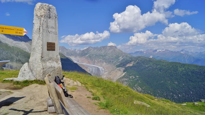
From 1877 to 1893 he spent his summers in the Villa Alp Lusgen, which he had built at Belalp. Naters made him an honorary citizen in 1887, and a monument in his honour was unveiled at Belalp in 1911.
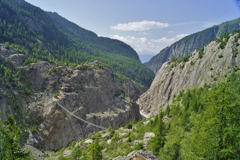
A bridge over the Massa gorge
Past Oberaletsch, the path drops down to the Massa and crosses it on the suspension bridge linking Belalp and Riederalp. The bridge spans the Massa gorge, and from the bridge you can see the tongue of the Great Aletsch Glacier.
The front of the Great Aletsch Glacier has been measured since 1870. Between 1990 and 2024, 32 of the 33 measurements show a retreat; only the one from 2018 to 2019 shows an advance. The glacier and the forest are badly affected by climate change.
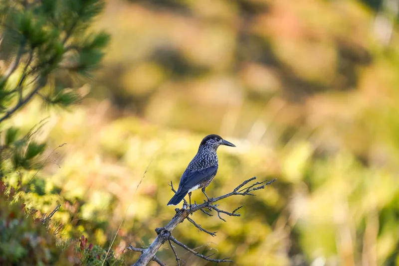
The Aletsch Forest, left to itself since 1933
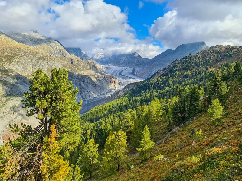
After the bridge you pass the Grünsee, then climb through the Teiffe Wald into the Aletsch Forest. Until the 1930s, people cut wood here, grazed cattle, burned lime and picked berries. Since the first lease in 1933, between the Ried-Mörel citizens' community, the Riederalp alpine cooperative and Pro Natura, the forest has not been exploited. It is part of a federal game reserve, the Federal Inventory of Landscapes (IFP) and the core zone of the Swiss Alps Jungfrau-Aletsch UNESCO World Heritage site.
The Swiss stone pines here grow only a few centimetres a year, but can live up to 1,000 years. They are "planted" by the spotted nutcracker, which hides pine nuts for the winter and doesn't find them all again. The Grünsee is a new body of water, and new peat bogs are now forming on its shores.
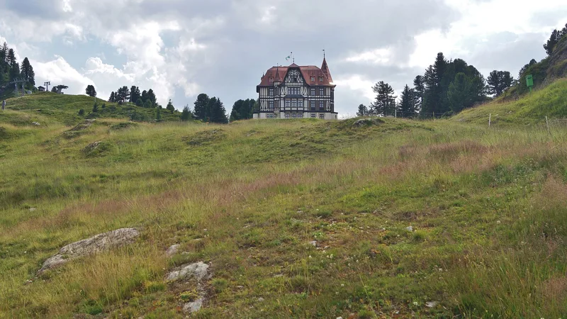
Riederfurka and a banker's villa
The last climb takes you to Riederfurka, at 2,056 m. Five minutes above it stands the Villa Cassel. The wealthy London banker Sir Ernest Cassel first spent a few summer weeks on the Riederalp in 1895: his doctor had prescribed rest and mountain air for stomach problems. He had his summer residence built on the Riederfurka, and it welcomed its first guests in 1902: leading figures from politics and high finance from England, Germany, France and America.
After Cassel's death in 1921, the villa and its chalet were turned into a hotel. Since 1976, Pro Natura has run a nature conservation centre here, with an alpine garden opened in 1979, an exhibition and a historic tea room, open from mid-June to mid-October (2024 opening times). Further down this page you'll find the next departures for the way back.
Every way to Riederalp, Riederfurka
3 starting points to reach Riederalp, Riederfurka. Pick yours: the 3D view shows it and “My day” recalculates.
Walking times without breaks. “Estimated” times are calculated on the swisstopo profile with a model fitted to the official SwitzerlandMobility stages; the shortest path may differ from the one on the yellow signposts: on the ground, follow the signs. Gradient: the steepest over 200 m of trail. Profiles share the same scale (length and altitude). Stations and car parks within 500 m of the start, according to OpenStreetMap.
In pictures
Hotel Belalp and the Aletsch Glacier, summer 2023
View from Belalp of the dust-covered tongue of the Aletsch Glacier (September 2014)
Tyndall monument, looking towards the Great Aletsch Glacier
Chapel of the Poor Souls, from 1916, at Üsser Aletschji
The Massa, its gorge and the suspension bridge
The Massa gorge and the suspension bridge across it, seen from the right lateral moraine of the Aletsch Glacier (Üsser Aletschji)
The Massa river, Naters-Riederalp (suspension bridge)
Aletsch Glacier and the Aletsch Forest Nature Reserve in autumn
Wild spotted nutcracker in the Aletsch Forest Nature Reserve
European larch forest in the Aletsch Forest Nature Reserve at golden hour in autumn
North-east view of the Villa Cassel from the track to Rieder Furka
The next few days
MeteoSwiss local forecast, updated every hour
Reading the MeteoSwiss forecast…
My day
Pick your day and start time: everything updates.
- Arrival at Riederalp, Riederfurka
- 12:15 3 h 45 of walking without breaks, starting at 08:30
The trail, kilometre by kilometre
Places are listed under the kilometre where you pass them. Drag along the profile: the marker moves on the 3D view too.
- under 10 %
- 10 to 20 %
- 20 to 30 %
- over 30 %
- fountain or water point
- toilets
Around the trail (250 m, OpenStreetMap, extract of 25/10/2026): 5 restaurants, 1 café, 4 fountains and water points, 2 toilets. Estimated time: the official walking time spread by effort (1 km on the flat counts as 100 m of climbing), start time set in “My day”.
Getting there and back
Riederalp, Riederfurka, 2,056 m
By car
Careful, this is one way: public transport back arrives in Riederalp, Riederfurka, not in Blatten, Belalp. Plan to get back to your car by public transport, or park at the finish and take the train to the start.
- Car park open-air, Oberi Täätschefree600 m from the start
Public car parks within 600 m of the start, according to OpenStreetMap: prices and number of spaces may have changed, check the signs on site.
Questions people ask
How long is the hike from Blatten, Belalp to the finish (Riederalp, Riederfurka)?
3 h 45 of walking according to SwitzerlandMobility, in this direction, not counting breaks. The other way: 3 h 45.
Is it hard?
SwitzerlandMobility rates this stage: fitness medium, technique medium. It is 740 m of descent over 9.9 km.
Where can I eat on the way?
6 restaurants, cafés and huts within 250 m of the trail, including Restaurant Bergstation, Pizzeria Aletschhorn, Restaurant Kristall. Where they are and their opening hours: below the profile.
Is there water and are there toilets on the way?
4 fountains and water points and 2 toilets within 250 m of the trail (survey of 25/10/2026).
Can I download the track?
Yes, as a GPX file for your watch or map app: “Download the track” button at the top of the page.
More hikes within 10 km
Official SwitzerlandMobility stages that pass within 10 km of this trail. Each card says whether its page is already up.
- Riederalp, Riederfurka → Märjelensee4 h 00Aletsch Panoramaweg, stage 211.0kmDistance820mAscent500mDescentTechnical mediumFitness medium. Page coming
- Riederalp, Moosfluh, loop2 h 35Aletschgletscher Aussichtsweg7.0kmDistance500mAscent500mDescentTechnical mediumFitness medium. Page coming
- Bitsch → Lalden2 h 25Rotten-Weg Bitsch–Lalden10.0kmDistance20mAscent60mDescentTechnical mediumFitness difficult. Page coming
- Ausserberg → Brig5 h 00Walliser Sonnenweg, stage 417.0kmDistance540mAscent880mDescentTechnical easyFitness medium. Page coming
- Birgisch → Eggen3 h 45Walliser Steppen- und Föhrenweg11.0kmDistance640mAscent680mDescentTechnical mediumFitness medium. Page coming
- Brig → Simplonpass5 h 20ViaStockalper, stage 112.0kmDistance1,600mAscent260mDescentTechnical easyFitness difficult. Page coming