
Hiking from Isenfluh to Schynige Platte
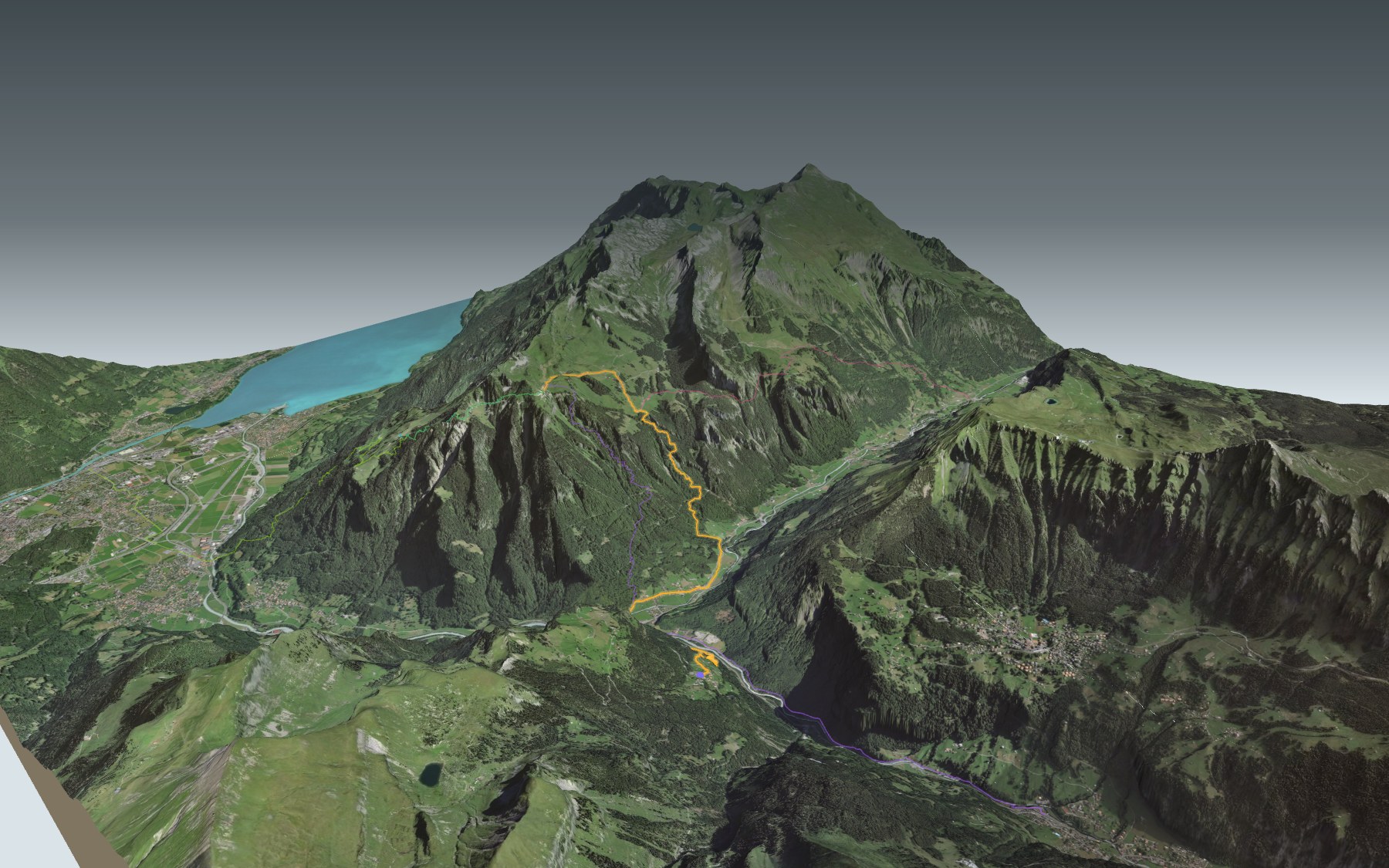
This ViaBerna stage starts by going downhill. From Isenfluh, a village set on a terrace above the valley of the White Lütschine, the trail drops to the valley floor at Zweilütschinen, then climbs all the way up to Schynige Platte station. It's rated difficult for fitness and medium for technique.
After Zweilütschinen you cross the Black Lütschine and walk through Gündlischwand and Rüdli. Then comes the long climb through the forest, via the Hubelwald and the Bortwald, up to the pastures of Usserläger and the Oberberg. The elevation profile shows you where it gets steepest.
Fancy a different start? Begin at Breitlauenen, a stop on the Schynige Platte railway, for a shorter day, or walk up from Lauterbrunnen, Burglauenen or Interlaken Ost: each starting point has its own colour in the 3D view and an estimated time under all starting points. From the station at the top you can also set off on the Panoramaweg Schynige Platte or on the next ViaBerna stage, from Schynige Platte to First.
At the top you'll find the alpine botanical garden with some 800 plant species from the Swiss Alps, the Schynige Platte restaurant and the 1893 cog railway to take you back down to Wilderswil. Check the next trains and plan your day before you set off. Looking for more in the area? See all hikes in the Bernese Oberland.
The story of the trail
What happened where you are going to walk, chapter by chapter.
Down before up
You start at 1,086 m in Isenfluh and finish at 1,967 m at Schynige Platte station. In between: 10.5 km, 1,350 m of climbing and 480 m of descent. The descent comes first: the trail drops to the valley floor before climbing again. The official walking time is 5 h 00 in this direction and 4 h 00 the other way.
The route follows mountain hiking trails for all or part of the way, and the climb from Zweilütschinen is a demanding one. At the start, the Waldrand restaurant is just off the trail; at the finish there's the Schynige Platte restaurant. The last water point marked near the trail is around Rüdli, before the climb: bring something to drink. On the trail, follow the signposts and check the conditions on the day.
Isenfluh to Zweilütschinen, on the old church path
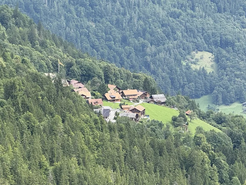
Isenfluh first appears in the records in 1319, as Ysenvluo. Until 1973 the village belonged to the parish of Gsteig; that year it joined the municipality and parish of Lauterbrunnen. Before the mountain road of 1962, a mule track led down to Zweilütschinen. In 1987 a landslide destroyed the road; the new one, with its spiral tunnel, dates from 1992, and the Isenfluh-Sulwald cable car from 1975. Shortly after the start, the trail passes right by the Isenfluhtunnel, then heads down the old church path, through the forest, past streams and waterfalls.
Down below, Zweilütschinen belongs to the municipality of Gündlischwand, where the Black and White Lütschine meet. A bridge was built here in 1580, at the fork of the two valleys, and the village has been a stop on the Bernese Oberland railways since 1890. From the station, the trail heads to the railway bridge over the Black Lütschine, then follows the old valley road to the village of Gündlischwand. In this municipality, from the late 16th century until 1715, iron ore from the upper Lauterbrunnen valley was smelted in the « Schmelziwald », the smelting forest; remains of the works, which included a blast furnace from 1682, still survive.
The big climb through the forest
After Gündlischwand, the trail passes Rüdli, then the real climb towards Iselten begins. It works its way up through the forest, via the Hubelwald and the Bortwald. On the way, in an area of loose rock, it squeezes through a rock gateway: locals call it the « Engelstor », the angels' gate, because if you're very good you're supposed to hear the angels sing here.
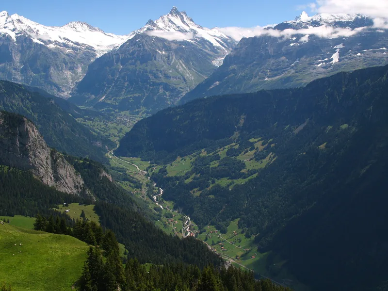
Higher up, the open pastures begin. The trail passes Usserläger, near Usser Iselten, then climbs to the place called Oberberg, where it meets the trail coming from the Faulhorn. From Schynige Platte, the view runs down the valley of the Black Lütschine, the one you've just left, with the Wetterhorn and the Schreckhorn in the background.
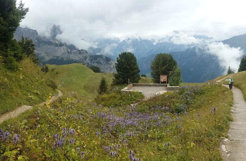
An alpine garden on the Iselten pasture
At the finish, the Schynige Platte alpine botanical garden awaits you, at 1,967 m. Around 800 plant species from the Swiss Alps grow here in their natural communities.
A first plan was considered as early as 1905, but came to nothing: the alpine cooperative refused to lease the land. In March 1927 the land on the Ausser-Iselten pasture was leased, and the garden association was founded on 10 June 1927. Work began in 1928 and the garden opened in 1929. It will celebrate its 100th anniversary in 2027. On 10 November 2026, it was announcing its reopening for 5 June 2027.
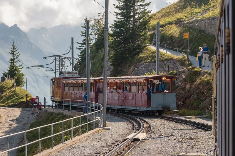
The 1893 train back down
At the station, the cog railway takes you back down to Wilderswil. The idea of a line came up in 1880; regular service began on 14 June 1893. The trains ran on steam until the end of 1913, then on electricity from 1914. Even today, the locomotive pushes the carriages uphill instead of pulling them, and the points are switched by hand.
In 2026, the train made its last run with visitors on Sunday 25 October. Before you go, check that it's running: further down the page you'll find the next departures.
Every way up to the top
5 starting points to reach Schynige Platte. Pick yours: the 3D view shows it and “My day” recalculates.
Walking times without breaks. “Estimated” times are calculated on the terrain profile with a model fitted to the official stages; the shortest path may differ from the one on the yellow signposts: on the ground, follow the signs. Gradient: the steepest over 200 m of trail. Profiles share the same scale (length and altitude). Stations and car parks within 500 m of the start.
In pictures
The valley of the Schwarze Lütschine, with the Wetterhorn, Mettenberg, Schreckhorn and Finsteraarhorn in the background, seen from Schynige Platte
The village of Isenfluh
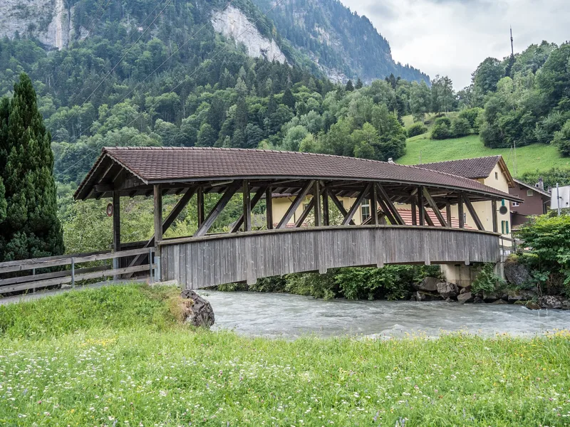
Footbridge over the Schwarze Lütschine, Gündlischwand, canton of Bern
Covered wooden bridge over the Schwarze Lütschine, Gündlischwand, canton of Bern
Zweilütschinen railway station
A train with the He 2/2 No. 14 locomotive and semi-open carriages arrives at Schynige Platte station (2010)
Trains of the Schynige Platte Railway passing at Breitlauenen station (2010)
The Schynige Platte Alpine Garden
Alpine sea holly (Eryngium alpinum) on Schynige Platte
From the Wetterhorn to the Breithorn, with the Eiger, Mönch and Jungfrau, above the Lütschine valley and the Lauterbrunnen valley, seen from Schynige Platte
The Dreispitz, the Morgenberghorn and Lake Thun seen from Schynige Platte
Isenfluh → Schynige Platte: when to go
Public transport serves the start every day until 25 April 2027 and from 6 May 2027 (and 1 and 2 May), according to the official timetable. The latest time to set off ranges from 15:23 in June to 10:41 in December.
- Public transport to the start
- every day
- 46 arrivals a day
- first arrival 7:05
- last 18:20
- Sun at the start, mid-January
- from 9:55
- rises at 8:09, hidden by the ridge
- Leave by, for 5 h 00 of walking
- 11:07
- arrive 1 hour before sunset, at 17:07
| Month | Sun at the start | Leave by | In the sun, leaving at 9:00 | Transport |
|---|---|---|---|---|
| December | 10:28 → 16:41 | 10:41 | 36 % | every day |
| January | 9:55 → 17:07 | 11:07 | 36 % | every day |
| February | 9:18 → 17:53 | 11:53 | 43 % | every day |
“In the sun”: the share of the path in sunlight under a clear sky, with the terrain worked out point by point. The path climbs to 1,970 m: today's snow and frost are in the weather and My day.
- Public transport to the start
- daily, 1 Mar to 25 Apr
- and also 28 other days
- 46 arrivals a day
- first arrival 7:05
- last 18:20
- Sun at the start, mid-April
- from 8:45
- rises at 6:41, hidden by the ridge
- Leave by, for 5 h 00 of walking
- 14:16
- arrive 1 hour before sunset, at 20:16
| Month | Sun at the start | Leave by | In the sun, leaving at 9:00 | Transport |
|---|---|---|---|---|
| March | 8:23 → 18:33 | 12:33 | 66 % | every day |
| April | 8:45 → 20:16 | 14:16 | 85 % | 25 of 30 days |
| May | 6:40 → 20:55 | 14:55 | 95 % | 28 of 31 days |
“In the sun”: the share of the path in sunlight under a clear sky, with the terrain worked out point by point. The path climbs to 1,970 m: today's snow and frost are in the weather and My day.
- Public transport to the start
- every day
- 46 arrivals a day
- first arrival 7:05
- last 18:20
- Sun at the start, mid-July
- from 6:40
- rises at 5:50, hidden by the ridge
- Leave by, for 5 h 00 of walking
- 15:19
- arrive 1 hour before sunset, at 21:19
| Month | Sun at the start | Leave by | In the sun, leaving at 9:00 | Transport |
|---|---|---|---|---|
| June | 6:32 → 21:23 | 15:23 | 100 % | every day |
| July | 6:40 → 21:19 | 15:19 | 96 % | every day |
| August | 8:14 → 20:39 | 14:39 | 88 % | every day |
“In the sun”: the share of the path in sunlight under a clear sky, with the terrain worked out point by point. The path climbs to 1,970 m: today's snow and frost are in the weather and My day.
- Public transport to the start
- every day
- 46 arrivals a day
- first arrival 7:05
- last 18:20
- Sun at the start, mid-October
- from 9:30
- rises at 7:46, hidden by the ridge
- Leave by, for 5 h 00 of walking
- 12:43
- arrive 1 hour before sunset, at 18:43
| Month | Sun at the start | Leave by | In the sun, leaving at 9:00 | Transport |
|---|---|---|---|---|
| September | 8:52 → 19:41 | 13:41 | 67 % | every day |
| October | 9:30 → 18:43 | 12:43 | 47 % | every day |
| November | 9:12 → 16:55 | 10:55 | 39 % | every day |
“In the sun”: the share of the path in sunlight under a clear sky, with the terrain worked out point by point. The path climbs to 1,970 m: today's snow and frost are in the weather and My day.
The next few days
Local forecast, updated every hour
Reading the forecast…
My day
Pick your day and start time: everything updates.
- Arrival at Schynige Platte
- 13:30 5 h 00 of walking without breaks, starting at 08:30
The trail, kilometre by kilometre
From Isenfluh
Places are listed under the kilometre where you pass them. Drag along the profile: the marker moves on the 3D view too.
- under 10 %
- 10 to 20 %
- 20 to 30 %
- over 30 %
- fountain or water point
- toilets
Around the trail (250 m): 2 restaurants, 6 fountains and water points and 4 toilets. Estimated time: the official walking time spread by effort (1 km on the flat counts as 100 m of climbing), start time set in “My day”.
- under 10 %
- 10 to 20 %
- 20 to 30 %
- over 30 %
- fountain or water point
- toilets
Around the trail (250 m): 1 restaurant and 3 toilets. Estimated time: the official walking time spread by effort (1 km on the flat counts as 100 m of climbing), start time set in “My day”.
- under 10 %
- 10 to 20 %
- 20 to 30 %
- over 30 %
- fountain or water point
- toilets
Around the trail (250 m): 4 restaurants, 1 café, 3 fountains and water points and 6 toilets. Estimated time: the official walking time spread by effort (1 km on the flat counts as 100 m of climbing), start time set in “My day”.
- under 10 %
- 10 to 20 %
- 20 to 30 %
- over 30 %
- fountain or water point
- toilets
Around the trail (250 m): 1 restaurant, 1 fountain or water point and 2 toilets. Estimated time: the official walking time spread by effort (1 km on the flat counts as 100 m of climbing), start time set in “My day”.
- under 10 %
- 10 to 20 %
- 20 to 30 %
- over 30 %
- fountain or water point
- toilets
Around the trail (250 m): 12 restaurants, 1 café, 14 fountains and water points and 10 toilets. Estimated time: the official walking time spread by effort (1 km on the flat counts as 100 m of climbing), start time set in “My day”.
Getting there and back
Back by public transport from the Schynige Platte stop
Next departures from Schynige PlatteReading the official timetable…
By car
From Isenfluh
Careful, this is one way: public transport back arrives in Schynige Platte, not in Isenfluh. Plan to get back to your car by public transport, or park at the finish and take public transport to the start.
- Car park roadsidepaid290 m from the start
- Car park open-airpaid320 m from the start
Public car parks within 600 m of the start: prices and number of spaces may have changed, check the signs on site.
Careful, this is one way: public transport back arrives in Schynige Platte, not in Breitlauenen. Plan to get back to your car by public transport, or park at the finish and take public transport to the start.
- Station Breitlauenenor by public transport0 m from the start
The nearest car park and stop for this start. Check the signs on site for the price.
Careful, this is one way: public transport back arrives in Schynige Platte, not in Lauterbrunnen. Plan to get back to your car by public transport, or park at the finish and take public transport to the start.
- Parkhaus Lauterbrunnenpaid60 m from the start
- Station Lauterbrunnenor by public transport0 m from the start
The nearest car park and stop for this start. Check the signs on site for the price.
Careful, this is one way: public transport back arrives in Schynige Platte, not in Burglauenen. Plan to get back to your car by public transport, or park at the finish and take public transport to the start.
- Car park50 m from the start
- Station Burglauenenor by public transport0 m from the start
The nearest car park and stop for this start. Check the signs on site for the price.
Careful, this is one way: public transport back arrives in Schynige Platte, not in Interlaken Ost. Plan to get back to your car by public transport, or park at the finish and take public transport to the start.
- Car park70 m from the start
- Station Interlaken Ostor by public transport0 m from the start
The nearest car park and stop for this start. Check the signs on site for the price.
Questions people ask
How long is the hike from Isenfluh to Schynige Platte?
5 h 00 of walking (official time), in this direction, not counting breaks. The other way: 4 h 00.
Is it hard?
Official rating for this stage: fitness difficult, technique medium. It is 1,350 m of climbing over 10.5 km.
Can I get back by public transport?
Yes. The Schynige Platte stop is at the finish. The next departures show live under “Getting there and back”.
Where can I eat on the way?
2 places to eat within 250 m of the trail: Waldrand, Schynige Platte. Where they are and their opening hours: below the profile.
Is there water and are there toilets on the way?
6 fountains and water points and 4 toilets within 250 m of the trail (survey of 25/10/2026).
Can I download the track?
Yes, as a GPX file for your watch or map app: “Download the track” button at the top of the page.
More hikes within 10 km
Official stages that pass within 10 km of this trail. Each card says whether its page is already up.
- © swisstopoSaxeten → Isenfluh5 h 20ViaBerna, stage 1313.0kmDistance1,100mAscent1,100mDescentTechnical mediumFitness difficult. Official waymarked stage
- © swisstopoBönigen → Iseltwald2 h 05Brienzersee Drei Wasserfälleweg, stage 17.0kmDistance320mAscent320mDescentTechnical easyFitness easy. Official waymarked stage
- © swisstopoBrünigpass → Interlaken8 h 15ViaJacobi, stage 930.0kmDistance860mAscent1,300mDescentTechnical easyFitness difficult. Official waymarked stage
- © swisstopoAeschi bei Spiez → Saxeten6 h 10ViaBerna, stage 1217.0kmDistance1,200mAscent950mDescentTechnical mediumFitness difficult. Official waymarked stage
- © swisstopoSigriswil → Interlaken4 h 45Panorama Rundweg Thunersee, stage 217.0kmDistance460mAscent700mDescentTechnical easyFitness medium. Official waymarked stage
- © swisstopoInterlaken → Spiez5 h 50Panorama Rundweg Thunersee, stage 320.0kmDistance740mAscent740mDescentTechnical easyFitness difficult. Official waymarked stage